I met with some of the wonderful folk at one of the New Jersey offices of the Nature Conservancy today. I am going to be doing some volunteer work in their skylands office and perhaps help out with some field work once or twice a month in the warmer months. They do good work both within the United States and globally. For more information about what they do, go here.
I am honored to have an opportunity to help out the Nature Conservancy locally in whatever very small ways that I can. I may not be able to write more than this here, but be assured that I am looking forward to volunteering with the Nature Conservancy.
CAL FIRE (CDF) S2T Tanker 71 working Sawtooth Complex Fire (2006)

Sawtooth Complex Fire (Sept. 2006), San Bernardino County CA. Photo Credit: U.S. Forest Service
Thursday, July 31, 2008
Wednesday, July 30, 2008
Global Warming and wildfires
I have been thinking about global warming for a few weeks now. I have known that the southwest is among the regions in the United States that have been experiencing an extended drought. I have to be honest that I had not thought all that much about the relationship between wildfires, the extended drought in the southwest, and global warming until I first heard about the wildfire outbreak in California in June.
When I began to spend more time reading about the wildfires in CA with a special focus on the basin complex wildfire, I started thinking about wildfires and global warming. Not that I'm in a position to make any sort of "educated" statement equating the recent wildfires in California with global warming. I'm not. At this point all I have are questions that I can only answer with hunches.
On the question of the relationship of the CA wildfires and the extended drought, it seems to me that there has to be a relationship between the two. It only makes sense. In my way of thinking, it is not exactly rocket science to say that when there is an extended period of drought conditions that their is a greater risk of wildfires. Are these wildfires more serious and occurring earlier? I seem to recall seeing something to that effect on either a National Park Service or a U.S. Forest Service wildfire website within the last couple of days. I'll need to go back and check this out to find my answer. What are the folk researching global warming and/or wildfires saying about global warming and wildfires? I'll have to check this out.
As I explore these and other questions over the coming weeks, I'll fill you in on some answers with links for more information on this blog, so stay tuned.
Tuesday, July 29, 2008
containment

The researcher part of me got the better of me this afternoon when I tried to find a definition of what it means when, for example, it was reported that the basin complex fire is 100% contained.
I finally found this glossary with short definitions of many of the terms that I have been reading about.
After reading some definitions in this glossary and the much longer Fireline Handbook (I should warn you that this Handbook is over 400 pages long and comes in at over 3 MB). I decided to keep it simple and not to worry about precise definitions of containment as used in connection to the basin complex fire because I was getting into multiple definitions. I also started asking myself questions like does the meaning of containment vary with measures used to fight individual wildfires? And does containing a fire in the NJ Pine Barrens mean something different than containing a fire such as the basin complex fire. I decided that the important thing is that the basin complex fire is contained.
The map was obtained on July 29, 2008 from http://165.221.39.44/incident/maps/large/1367/0/
hoses
For those of us who have had to deal with managing garden hoses . . .
After reading this post from Kelly O'Brien's blog I have different view of what I used to call my battles with my garden hose:
http://thefirelane.blogspot.com/2008/07/and-you-think-that-your-garden-hose-is.html
After reading this post from Kelly O'Brien's blog I have different view of what I used to call my battles with my garden hose:
http://thefirelane.blogspot.com/2008/07/and-you-think-that-your-garden-hose-is.html
Monday, July 28, 2008
basin complex fire contained
A very brief update on the basin complex fire. kusp radio posted a report from the U.S. Forest Service reporting that the fire is at 100% containment. More work has yet to be done.
I had company this past weekend so did not have a chance to report that the voluntary evacuations were lifted either late Friday night or Saturday.
I'll post more on this in a day or so.
I had company this past weekend so did not have a chance to report that the voluntary evacuations were lifted either late Friday night or Saturday.
I'll post more on this in a day or so.
Thursday, July 24, 2008
Photos of Basin Complex Fire
Speaking of Incaweb, here is a link to photos of the Basin Complex from Incaweb. You will also find photos here. If you take time to look at Life in the Firelane, you will also find photos. If you check out some of the other links that I have referred to in my earlier postings on the Basin Complex Fire you will probably find other photos.
Fighting Wildfires in the Everglades
I found this slide show of fire fighting equipment on the Everglades National Park website. If you put your cursor at the top of the photo during the slide show you will see the caption.
I suspect that some of the equipment is the same for all wildfires. However, one piece of equipment that you will see is called a flapper. It looks to me like it is made to fight fires in grasslands. Then again what do I know?
For photos of the Mustang Corners see incaweb and this photo gallery on the Everglades National Park webpage.
Wednesday, July 23, 2008
Maps of the Mustang Corners Fire
Wildfires in Florida in May 2008
On or about May 14, 2008 wildfires started burning in the Everglades National Park in South Florida. By the time the fires were contained in early June, just over 39,000 acres were burned. Known as the Mustang Corners fire, this fire followed a series of fires in the Palm Beach area, in Brevard County south of Daytona Beach, that burned 12,000 acres. Other fires included about 19,000 acres on the south end of Lake Okeechobee, 1,300 acres in the Florida panhandle near Apalochicola, 257 acres in the Ocala National Forest in Central Florida and a couple of smaller fires in the Everglades National Park.
Information on the Mustang Corners fire in Everglades National Park may be found here and here. The two smaller wildfires in the Everglades National Park are very briefly referenced in this press release. A CNN report on May 18 reviews the then current status of the Mustang Corners fire as well as other Florida wildfires. What is probably the final incident report on the Mustang Corners fire may be found on InciWeb. Inciweb goes down periodically so if the link does not work, try back again later.
Damage reports for the Brevard Çounty wildfires may found in this press release issued by the Brevard County Office of Emergency Management. They report that 194 buildings were affected by these wildfires with 42 residences being destroyed.
CNN reports on the arrest of a man alleged to have caused some of the Brevard County fires. Both InciWeb and the National Park Service report that the Mustang Corners fire was caused by humans.
Tuesday, July 22, 2008
Coming attractions
I am going to continue posting updates on the basin complex fire here and other issues related to this wildfire.
I am however going to start moving to writing about the Everglades. I believe that I mentioned several days ago that a couple of months ago there was a major wildfire in the Everglades caused, I believe, by an arsonist. I first got interested in the Everglades for a project I did in graduate school, beginning a long love affair with the 'Glades. So it seems fitting to devote some time to the "Glades.
No, I have not forgotten about New Jersey. I want to write about the Pine Barrens, but it might take me a couple of weeks or so before I get to this.
update on basin complex fire as of July 22 AM

kusp radio is reporting that the basin complex fire is 72% contained with over 137,000 acres burned to date. Voluntary evacuation orders remain in effect. I have not yet mentioned that one of contributing factors to the spread of this fire is sudden oak death in tan oaks. Stands of dead tan oaks have provided fuel for the fire. For more detail see this summary from the U.S. Forest Service (posted on July 22). Forest Service map obtained from http://www.kusp.org/fire/images/map_basin_7_22.jpg on 22 July 2008.
Monday, July 21, 2008
update on all fires in California
The focus of my writing has been on the basin complex fire. I want to pause a moment and provide an update on the status of other fires burning in California. According to the CAL FIRE webpage, maintained by the California Department of Forestry and Fire Protection, there are still 33 active fires burning. At the peak of wildfire activity (since 20 June), there were 2,096 wildfires reported by state, local, and federal fire fighting agencies. A total of 953,907 acres have been burned to date.
According to todays fact sheet 123 residences, 1 commercial building, and 138 out buildings have been destroyed. These are the stats for threatened structures: 4,958 residences, 139 commercial buildings, and 2,166 out buildings. There have been 15,573 personnel used to fight the fires to date. Evacuation orders are still in effect for portions of Humboldt, Trinity, Shasta, Lake and Mendocino counties. What CAL fire calls precautionary evacuation orders (aka voluntary evacuation orders??) are in effect for portions of Monterary (basin complex fire) and Trinity Counties.
For those so inclined, you can go here to download a map of what are known as the June Lightening fires in California. It is an adobe reader file. I spent a little time looking at the map. Fires range from counties near the Oregon border south to Santa Barbara County.
As I was watching the weather channel a little while ago, they reported on a wildfire of unknown origin burning on 100 acres outside Denver.
Saturday, July 19, 2008
Apple Pie Ridge
I was first introduced, so to speak, to the Curtis brothers, owners of 55 acres known as the Apple Pie Ridge not far from the town of Big Sur CA while reading this entry from the Cachagua Store blog. Briefly, the Curtis brothers with the help of family, friends, and tenants set back fires and other fire fighting techniques and were successful in defending their homes from being burnt down by the fire. They did so because they were told that firefighters would be able to defend their homes from the fire. Their success came at a cost with the younger brother being arrested for arson.
The LA Times has a very good article about the Curtis Brothers, Micah and Ross, in the July 7 edition of the paper. I am accessing this article on July 19 and I'm not certain how much longer it will be freely available.
Reading these accounts of the defense of Apple Pie Ridge got me thinking. If I had heard national news media accounts of the defense of Apple Pie Ridge and the arrest of Ross Curtis for arson, I might have been horrified because what they did would have been completely foreign to me. I heard no such reports, nor have I been able to find any on the web. I am not horrified, quite the contrary. I found myself thinking about the courage and strength of character displayed by the Curtis family, their friends and tenants. They are the kind of people that I would want as neighbors.
Before closing I want to say that members of the Curtis family will be the first to tell you that they are not advising people to set backfires to save their homes from forest fires. Tyson Curtis, Micah's son commenting on an article on the LA Times article has this to say (comments made on July 11 from 3:01 PM to 3:25 PM PDT):
I have so much to say, but i'll be as succinct as possible. To those in favor of what we did: I DO NOT advise people to defend their homes and set back fires... we had two experienced fire fighters with us that understood the technique, and this is evidence in their flawless execution of fighting fire with fire. In fact, since we know every inch of our property I'm sure we executed our back burns better than any fire fighter could.
Second, this was more leading the fire than back burning, we were burning ahead of the fire only when it was several hundred feet from us... and so there was NO chance anyone was between us and that fire. Also, this made the fire burn down hill, instead of up, which kept the fire under control and actually put LESS fire fighters and neighbors at risk because it burned slower and more manageably.
I would like to thank the one fire crew who came up thursday morning and helped direct the back burn that we set in motion... (while we were cutting hand lines on the back side of the ranch where the fire was making a second assault) but as for the higher ups... well this is the third time our ranch has burned over, and i have little faith you'll be there when my kids are fighting the next one.
And a lot of people seem to think we waited until the last second to cut brush and clear around our houses; this isn't true. We cut brush every winter and maintain fire clearance around our ridge top... but in steep terrain flames can clear three or four hundred feet of clearance. The clearing we were doing before the fire was added precaution and when the fire crews showed up to evaluate our ranch it was nearly clear cut; they STILL thought it was indefensible... and were obviously wrong.
And as for burning down our neighbors houses, the main fire was coming, and if we hadn't taken action in a way that we could control the fire... it could have been disastrous for our neighbors. The proof of this is that everyone i've seen has thanked me for stopping the fire on top of our ridge, and not a single person has questions our means of doing so. Unless you know the terrain you wouldn't understand what we did... any fire fighter should know that!
The fire burned all the way to highway one a mile south and north of us... and it would have done just that here too, which would have threatened the seven homes at the bottom of our ridge.
(obtained from http://www.latimes.com/news/local/la-me-backfire-gb,0,2173086
.graffitiboard on 19, July 2008)
Update on basin complex fire as of 7/18/08 PM
Kelly O'Brian, the author of the Life in the Fire Lane blog, who is also affiliated with KUSP radio (NPR) reported last night that the danger is not over for the residents of Jamesburg and Cachagua CA. These are the areas where the mandatory evacuations were lifted Wednesday night (July 16), and downgraded to a voluntary evacuation.
In an interview with Rick Hutchinson of CAL fire, Rick reported that the danger is not over for residents of Cachagua and Jamesburg. Specifically, they may have to go back to a mandatory evacuation at much shorter notice than the last time. The interview may be found here.
As I write this it is just past 11 AM EDT on Saturday, July 19. I checked my usual sources on the internet and have no later updates.
Kelly lives in Jamesburg and my friend lives in Cachagua.
I'll keep you updated .
Friday, July 18, 2008
Some mandatory evacuations lifted in basin complex fire
Kelly O'Brian, author of the Life in the Fire Lane blog, reported last night that many but not all of the mandatory evacuations have been lifted, at least temporarily.
I want to point out that many of those affected by these mandatory evacuations chose to stay behind, sometimes separated from their loved ones, to defend their property from the fire. Apparently this is not unheard of in this part of the country. This meant that they could get out.
If I understand correctly, at least some of the mandatory evacuation zones were a few miles from active fires so those staying behind were not necessarily in imminent danger from the fire. Where some of the zones were declared mandatory evacuation zones so that fire fighters could have needed road and other access to do their work. I think.
Five Zen Monks fight fire
The story of five Zen Buddhist Monks from the San Francisco Zen Center on Tassajara Road in Carmel Valley CA who returned to their compound after an evacuation on July 9 to fight the fire in their compound.
You may find a link to their story on this web page along with links to various updates.
Finally check out at least some of these awesome photographs taken by the five monks.
You may find a link to their story on this web page along with links to various updates.
Finally check out at least some of these awesome photographs taken by the five monks.
How the Basin Complex Fire got started
According to today's report (18 July) of the status of the Basin Complex Fire in Los Padres National Forest (near Big Sur) in CA, over 128,000 acres have burned. It is 65% contained. The estimated total cost just to fight this fire is $53.8 million. These figures were obtained from Inci web's basin complex fire page.
The fire was started by lightening on June 21, as were several of the other wildfires that are or were still burning. In my wonderings on the internet today I found this account with some photos from someone who was on a trail with a view of the start of the fire.
The fire was started by lightening on June 21, as were several of the other wildfires that are or were still burning. In my wonderings on the internet today I found this account with some photos from someone who was on a trail with a view of the start of the fire.
Wednesday, July 16, 2008
NJ Forest Fire Service helping fight CA wildfires
The NJ Forest Fire Service has sent 31 members to CA to help fight the wildfires.
For more information see this press release from the NJ Forest Fire Service.
For more information see this press release from the NJ Forest Fire Service.
Basin Complex Fire

I have been following one particular fire that is still burning in CA, the fire known as the basin complex fire currently burning in the Los Padres Forest (near Big Sur).
Why am I writing this? Perhaps it is to make a statement that this blogger who lives in the northeastern United States cares deeply about what is happening. Mention of your fires may be relegated to a small corner of my newspapers (if mentioned at all). I think about all affected by the basin complex fire and the other fires still burning in California every day. Perhaps what I am writing is an act of prayer, of letting you know that you are not forgotten.
One thing that has touched me in my readings of a couple of blogs as well as some e–mail updates I am getting from a friend who is living very near the basin complex fire is their strength of character, and the love they hold for their forest. I suspect that most know of the danger of living where they live, in an area known for fires. I am moved beyond words, so I won’t even try.
But to set a very brief context, please allow me to speak very briefly about living in fire–prone areas and evacuations.
Just as there are things that residents in areas such as Florida and the Gulf of Mexico do to hurricane–proof their homes there are things that people living in fire–prone areas can do that may reduce the chance that the home will be burned down:
clearing up debris from around the house, using flame retardant roofing shingles, not planting trees close to the home and the like. I suppose for many, these measures are a part of life. See this July 2008 graphic from The National Geographic Magazine about ways to make a house less forest-fire prone.
The house where my friend lives is, I think, still in a voluntary evacuation zone. But at last word, she was only one mile from a mandatory evacuation zone. So, since she is still voluntary, she can come and go as she pleases. But once a voluntary goes to a mandatory evacuation, residents are not permitted to go back to their houses after they leave. So, residents in a mandatory zone are living like rats in cages as some blogger’s have put it. They cannot go to the store. And if someone in his or her family was out of the house when the mandatory evacuation went into effect, well tough luck. Of course, hurricanes and floods can lead to evacuation orders. Not that I have been through either I have not. For more information about the meaning of various types of evacuations, see this webpage (courtesy of kusp radio) with definitions of the various types of evacuations.
If anyone in or near the region affected by the basin complex fire in CA or who has been affected by other forest fires in the west has any comments that you would care to make, I'd love to hear from you! :-)
For more information on the basin complex fire see:
1. Life in the fire lane
2. Cachagua CA Fire Department. Cachagua is one of the communities affected by the basin complex fire.
3. Inca web: basin complex wildland fire information (this site has current information about the fire. It gets a lot of traffic and you may have trouble accessing the site.)
4. kusp radio (near Big Sur CA, I think). This site has current fire maps, evacuation orders, updates, good links.
5. Monterey CA (I think) TV station (ksbw): videos, links
6. SurFire08 (community website)
Map of fire as of July 14 obtained from http://www.kusp.org/fire/images/map_basin_7_14_large.jpg on 16 July, 2008
copyright 2008 K. Tyler Miller
Monday, July 14, 2008
Speaking of fires
When I was in grad school I spend a lot of time reading about and then writing about urban encroachment on the Everglades in Florida. So, one of the things that I read about was the role of fire in the ecology of the Everglades. I hope to write about the Everglades and the recent fire of a few weeks ago in a later entry.
Wednesday, July 09, 2008
Fires in CA
I am switching gears.
Before going to Vermont, I had heard about wildfires in CA as well as fires in the Everglades in Florida in the late spring. While we were in Vermont, I heard about all the wildfires in CA on National Public Radio, especially the one in Big Sur.
These wildfires have touched me in a way that I can quite explain here.
Rather than try to find wholly inadequate words to explain what is going on, for those of you are interested, here are some websites where you can find out more.
The Big Sur community has a website called surfire2008.org There is good blog with updates about the fires and a link for donations. A friend of mine from the region has assured me that the money will go to people who have lost their homes and possessions. And they take paypal and snail mail donations.
Here is another fire blog, this one by a woman who lives not far from the basin complex fire.
According to the California Department of Forestry and Fire Protection, there were 1,781 fires at the peak, 1,458 fires are contained, leaving 323 fires still burning. Over 675,000 acres have burned. Many but not all the fires were started by lightening.
This is a local television station, ksbw, that has newsupdates and links on a webpage devoted to the fires.
Sunday, July 06, 2008
When the ordinary is extraordinary in VT: wildflowers
One of the nice things about coming to my cabin in June is seeing all the wildflowers around my cabin and in my meadow. They are especially beautiful this year, and I have never seen so many different varieties. Some of these flowers may be from the garden that my great-aunt Marjorie keep fifty some odd years ago. I suspect that birds and other natural processes account for some of the others. Some are probably invasives pr weeds and all are beautiful. Funny, what I consider a "weed" in New Jersey" is not a "weed in Vermont.
In any case, I have enjoyed seeing these flowers this year because they are natural. Here are some pictures of some of these flowers.
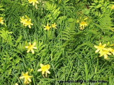

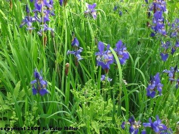
In any case, I have enjoyed seeing these flowers this year because they are natural. Here are some pictures of some of these flowers.


When the ordinary is extraordinary in VT: glacial erratics


A couple of days before I left for Vermont I was having an e-mail correspondence with a friend of mine from Australia. For no particular reason, I sent him five photos of my property in Vermont and the surrounding area. One of these photos is the photograph of the Lake in front of my cabin taken at sunset showing a large granite boulder sitting in about eight feet of water.
This is a favorite photo of mine (see the top photo), and I have about five different digital photos and who knows how many photos that predate digital photos. I have showed some version of this photo to many people over the years.
When my friend wrote back to me thanking me for the photos, he inquired:
“I find myself wondering how the rock got there?”
This very simple question got me thinking. I wrote back telling him the very short story of the geological history of this part of Vermont, that when glaciers passed over this area several thousand years ago large boulders were dropped at random and haphazardly. When the ice sheet retreated, these boulders, sometimes called glacial erratics were often left standing alone in a field, in a forest, or even in a body of water. In case you are wondering, according to local geologists, many of these erratics are granite.
Because it was only a few hours before my imminent departure, I had time for only the briefest of explanations to my friend, who also marveled at the trees. I wrote him a shorter version of the preceding paragraph and sent him some Internet links explaining local geology and forestry.
I was very glad for my friends question about how the rock got in the lake for it made me think about how unusual this rock is. I have taken this rock for granted for more years than I care to admit here. I never wondered how the rock got there because I always knew how the rock got there. I tried to put myself in the shoes of someone who had never been to this part of America before. I don’t take the erratics that are all too common in this part of New England for granted any more. I wanted to find one photograph that showed an erratic boulder in all its glory to show my friend (bottom photo). And I remembered this erratic on the high spot of a shoulder of a mountain. This photo is for my friend in Australia.
back in the land of the internet
I am back in the land of the internet. That is I choose not to have internet access (in this case dial-up) at my cabin in Vermont.
I'll tell you a secret. The entries that I wrote from 19 June on were all written before I left home. I did not make any postings from Vermont. But I did write two more entries that I will post now. One is on wildflowers and the other is on glacial erratics (written for a friend in Australia).
I'll tell you a secret. The entries that I wrote from 19 June on were all written before I left home. I did not make any postings from Vermont. But I did write two more entries that I will post now. One is on wildflowers and the other is on glacial erratics (written for a friend in Australia).
Wednesday, July 02, 2008
The ordinary is extraordinary in VT: maple sugar taps
Many of you, at least in the northeastern part of the United States know that Vermont is well known for its maple sugar. In march of every year when the days start to get at or above freezing and the nights are still cold, the sap in the sugar maples run. Maple sugaring is still very much alive and well in the northeast kingdom, as it is in other sections of Vermont.
Maple syrup comes from a stand of Maple trees, usually Sugar Maples, known as a sugar bush. I say my first and only sugar bush when I was fourteen, I won't tell you how many years ago that was. I was with my Dad and my Great-Uncle John in his wood plot on some land he owned on the side of the mountain adjoining the Lake. Uncle John had on old jeep that he used in Vermont, the type of jeeps that you might have seen in movies about World War II except it was gray and not olive drab. There was an old woods road that he could use to access his land from one of the town gravel roads.
Uncle John's idea was to cut a road from the old woods road down to the highway so he would be able to access his land. By this time, Uncle John was in almost seventy. My Dad and I went along to help him on this task that took about three days. I had a great time, by the way. Uncle John had an old chain saw that he used and I cleared brush and perhaps hacked away at smaller trees with a hatchet or a camp axe.
As we drove along this old woods road the first day, Uncle John pointed out a sugar bush owned by one of the local farmers complete with taps (in the trees) and tubing. I thought this was pretty neat.
I have tried without too much success to find this old road, all these years later, including a concerted effort about twenty-five years ago with no luck. Uncle John sold his land in the woods to his younger brother before he died. Uncle John got sick with what we know now as post-polio syndrome a couple of years later. For he had polio in one of the polio epidemics in the first part of the twentieth century when he was about ten. I don't think that he ever used the road that we built down to the highway, but I had a lot of fun and remember the sugar bush.
Subscribe to:
Posts (Atom)