CAL FIRE (CDF) S2T Tanker 71 working Sawtooth Complex Fire (2006)

Sawtooth Complex Fire (Sept. 2006), San Bernardino County CA. Photo Credit: U.S. Forest Service
Wednesday, March 31, 2010
NJ Forest Fire Service photo montage
This video is a nice photo montage of pictures from the New Jersey Forest Fire Service set to music.
Tuesday, March 30, 2010
Here we go again: 2010 Floods redux
I am again taking a break from posting about aerial wildland firefighting to report on the ongoing flooding concerns here in NJ. I have written about flooding in Little Falls NJ here and here. I want to say at this juncture that there are other Rivers in New Jersey that are flooding, for example the Millstone at Blackwell Mills, the Wanaque River at Pompton Plains, the Passaic River at Pine Brook (not far from Little Falls), and the Assunpick Creek in Trenton to name a few. Since I have written about the flooding at Little Falls on two prior occasions, I will follow up with the flooding of the Passaic River at Little Falls (the subject of the video that I embedded).
Forecasts today call for the Passaic to crest at Little Falls at about 8.2 feet (moderate flooding) late in the day tomorrow Wednesday. If this forecast holds, this will be over three feet lower than the flooding of a couple of weeks ago (11.76 feet -- major flooding).
The New Jersey Forest Fire Service (NJFFS) is providing assistance to two communities affected by today's floods, Little Falls and Fairfield, see this report for more information. As I understand it, these communities requested the assistance of the NJFFS sometime yesterday to aid local officials in working the floods. The report I linked to provides an update on how the flood is affecting New Jersey. Earlier reports, posted New Jersey's current round of flooding may be found here and here. All these reports were posted to the hotlist forums at wildland fire. Thank-you to the NJFFS for helping out with the flooding.
Those of you who are interested in following along on the status of flooding in New Jersey may want to see this page, from the Advanced Hydrological Prediction Service of the Mt. Holly Office of the National Weather Service.
While I am at it, flooding is affecting other areas of the Northeastern United States including but not limited to Long Island NY, Connecticut, Rhode Island, and Massachusetts.

Revised start dates for NJFFS contract aviation resources
A few days ago I wrote about the start dates for the SEAT contracts here in New Jersey, see this article. Due to the wet weather that we are having in New Jersey, the New Jersey Forest Fire Service has revised the start dates for the SEAT contracts. The new start dates are:
Division A (northern NJ)
Aeroflex -- Alpha 2 -- 300 Ag-Cat -- 4/3 through 5/12 -- 40 Days (off contract)
Aeroflex -- Alpha 3 -- 300 Ag-Cat -- 4/3 through 5/12 -- 40 Days (off contract)
Division B (central NJ)
Miller -- Bravo 1 -- 602 Air Tractor -- 4/3 through 5/19 -- 47 Days
Allaire -- Bravo 2 -- 300 Ag-Cat -- 4/3 through 5/5 -- 33 Days
Division C (Southern NJ)
Downstown -- Charlie 1 -- 602 Air Tractor -- 4/3 through 5/12 -- 40 Days (off contract)
Hammonton -- Charlie 2 -- 300 Ag-Cat -- 4/3 through 5/12 -- 40 Days (off contract)
Division A (northern NJ)
Division B (central NJ)
Miller -- Bravo 1 -- 602 Air Tractor -- 4/3 through 5/19 -- 47 Days
Allaire -- Bravo 2 -- 300 Ag-Cat -- 4/3 through 5/5 -- 33 Days
Division C (Southern NJ)
Monday, March 29, 2010
British Aerospace BAe-146 and Berieve Be-200
Bill Gabbert of Wildfire Today has recently reported on the status of two fixed-wing aircraft that might have implications for aerial wildland firefighting here in America: the British Aerospace BAe-146-200 and the Russian Berieve Be-200. Some of you may already be familiar with these developments, either through Bill's reporting or from other sources. I found these articles of interest, and am passing them on to you.
Bill reported in an article posted on March 28 that Tronos has converted a British Aerospace BAe146-200 for use as an air tanker. The tanker, which made a drop on a fire in Prince Edward Island Canada lastAugust October has retardant tanks capable of holding 3,000 gallons of retardant. Bill also reports that Minden Air is in the process of converting another BAe-146 for use as a tanker. You will want to see Bill's article located here for more details, including information on approvals and certifications that have to happen before this tanker can fly in the U.S.
And those of you in California may get a chance to see the Russian Berieve Be-200 air tanker, an amphibious aircraft. The Be-200 is scheduled to appear at the Santa Maria (CA) airport for one week starting April 10. If approvals are obtained, plans call for a demonstration of the Be-200 in action, scooping water from Lake Cachuma and then making a demo drop. Negotiations between the U.S. and Russian governments, facilitated by David Baskett of Santa Maria, are ongoing. Mr. Baskett hopes to acquire 10 of these aircraft for eventual use as air tankers in America.
The Be-200 cleared customs in Alaska last week on its way to South America for a tour before a planed re-entry into the U.S. For more details, including some links to youtube videos of the Be-200 in action, see this article written by Bill Gabbert on Wildfire Today. Bill also noted that a website has been set up for the visit of the Be200.
I'd like to thank Bill for his blog, and for his good write-up on what is happening with both of these aircraft. I was aware of the pending visit of the Be-200 but other projects kept me from finding out more details. Then I saw Bill's article, along his article on the BAe-146, making my life easy! Thanks Bill!
Bill reported in an article posted on March 28 that Tronos has converted a British Aerospace BAe146-200 for use as an air tanker. The tanker, which made a drop on a fire in Prince Edward Island Canada last
And those of you in California may get a chance to see the Russian Berieve Be-200 air tanker, an amphibious aircraft. The Be-200 is scheduled to appear at the Santa Maria (CA) airport for one week starting April 10. If approvals are obtained, plans call for a demonstration of the Be-200 in action, scooping water from Lake Cachuma and then making a demo drop. Negotiations between the U.S. and Russian governments, facilitated by David Baskett of Santa Maria, are ongoing. Mr. Baskett hopes to acquire 10 of these aircraft for eventual use as air tankers in America.
The Be-200 cleared customs in Alaska last week on its way to South America for a tour before a planed re-entry into the U.S. For more details, including some links to youtube videos of the Be-200 in action, see this article written by Bill Gabbert on Wildfire Today. Bill also noted that a website has been set up for the visit of the Be200.
I'd like to thank Bill for his blog, and for his good write-up on what is happening with both of these aircraft. I was aware of the pending visit of the Be-200 but other projects kept me from finding out more details. Then I saw Bill's article, along his article on the BAe-146, making my life easy! Thanks Bill!
Saturday, March 27, 2010
NJ Paramount Fire - probable cause and air attack footage; Rx burns
Local media is reporting that investigators into the cause of last weekends Paramount Fire that burned 540 acres in Barnegat NJ may have been intentionally sent, see for example the video as well as reports by the Asbury Park Press here and here.
As you watch the video, you will see footage of what I believe is an Air Tractor 602 dropping slurry on the fire.
And yes, as the news broadcaster at myfoxphilly reported, it is prescribed burning season here in New Jersey. The Rx burning season has been hindered by recent snow and rain storms, see this article from the Atlantic City Press for more information.
Update #2: 2010 floods in NJ

While flood waters have receded, lets not forget that people in Little Falls, Bound Brook, Wayne and elsewhere in NJ will be cleaning up after these floods for awhile yet. As will folk in New England and South Dakota.
Friday, March 26, 2010
Firefighting Airtankers
A friend of mine sent me a link to Rambling Chief's article about this video. This is a short clip from a longer (80 minute) film, Firefighting Airtankers: "Aerial Assault", an Alan Simmons / Firestorm Video Production. In this clip you will see footage of the:
Grumman S-2 (CAL Fire)
Lockheed Neptune P2-V
Lockheed Orion P-3
Canadair 215 and 415
McDonnell Douglas DC-10 Tanker 910
There is some great footage in this clip, and I am looking forward to seeing the 80-minute version. At the end of the clip, you will see some footage of some vintage airtankers. To get the full effect, click on the video above to see it in a larger format directly from youtube.
Wednesday, March 24, 2010
Contract aircraft: New Jersey State Forest Service
Yes, in spite of all the rain that we have had in New Jersey, our spring fire season is upon us. As I understand it, the contract start date for the NJ Forest Fire Service SEATs was pushed back a few days because of the wet winter. At this time of year, fuels can dry out quickly, especially when there are winds and/or low relative humidity.
The New Jersey Forest Fire Service (NJFFS) divides the State up into three divisions, division A is includes counties in northern NJ, division B is central NJ, and division C is southern NJ. For more information on this geography, current wildfire danger and restrictions including a map go this NJFFS webpage.
Contract SEAT aircraft go on contract starting March 31 around the State for 33 to 47 days depending on type of SEAT and location. This year, and as they did last year, the NJFFS has contracted for AgCats as well as two Air Tractor 602s. For more information including some links to photos and videos, go here.
A couple of weeks ago a tentative schedule for contract aircraft was posted here. As I understand it, the call signs -- alpha, bravo, and charlie -- for the aircraft refer to the division where they will be based. Two Agcats will be based in northern NJ (Div. A) at Aeroflex-Andover Airport from March 31 through May 9. One AgCat (Allaire Airport, 3/31 to 5/2) and one AT-602 (Miller, 3/31 to 5/16) will be based in central NJ (Div. B). Finally one AgCat (Hammonton Airport) and one AT-602 (Downstown Airport) will be based in southern NJ (Div. C) from March 31 through May 9.
Tuesday, March 23, 2010
Update: 2010 floods in NJ
One of the areas in New Jersey that saw flooding last week is Little Falls, along the Passaic River.

The map above, obtained from this NWS webpage shows the location of the river gauge (the red dot). If you go to that webpage, you will also see a graph of river levels for the current seven day period. The graph shows recent, current and forecast levels of the Passaic River at Little Falls. Today's graph, shown below, shows that the current level is just above flood stage. The river is expected to crest sometime in the period from late afternoon Wednesday (3/24) into Thursday (3/25). Now, I got a graph (not shown here) last week showing that the River was at 11.76 feet on Tuesday, March 16. Still, this weeks flooding will only exacerbate the situation.

Monday, March 22, 2010
Paramount fire in NJ contained
The Paramount fire that I wrote about yesterday that burned 540 acres has been contained. I suspect that the rain that we are currently having here in NJ will finish the job. Here are two youtube videos from sectionB10 of the NJ Forest Fire Service showing images from the Paramount Fire. In the first video, shot from the east flank of the fire, you will see a back-fire that is "eating its way towards the main fire." Click on the video to see the information box supplied with the video for more information.
The next video shows the staging area for the fire.
The next video shows the staging area for the fire.
Sunday, March 21, 2010
NJ - Paramount Fire
The Paramount Fire, currently burning in Barnegat NJ in or near the Pine Barrens, has been burning since sometime yesterday (Saturday, March 20). The last offcial report that I saw dated earlier today, see this thread from wildland fire, indicated that the fire had consumed 488 acres and is 85 percent contained. About sixty residents were evacuated yesterday and are now home.
At least one contract aircraft, an Air Tractor 602, was deployed. The tanks in the AT-602 have a capacity of 600 gallons.
I don't know exactly where the fire is, but thanks to the report on the webpage of Section B10 of the New Jersey Forest Fire Service, I have a pretty good idea of the general vicinity where the fire is located. The image below that I pulled from google earth will give you an idea of where I think it is located, near County Route 554 (which I believe is also W. Bay Ave.) on the west side of the Garden State Parkway.

While you are at the Section B10 webpage, check out the links for photos from the Paramount fire. And they have lots of very cool information about the goings on of the NJ Forest Fire Service. I have this page bookmarked and check it frequently.
For media reports and photos go here and here. According to media reports, some of this area was last burned in 2008. The media also reported that although the ground was still wet, the tops of the trees were dry, providing plenty of fuel for the fire.
Friday, March 19, 2010
Martin Mars in action
I've been busy this week with a couple of projects and other life events. So, I have dug through my stored videos from youtube and found this video from the 2009 Station Fire of the Martin Mars loading water and than making a drop on Mt. Wilson Observatory. I had the privilege of watching some footage of the Martin Mars last summer from a live stream out of one of the LA television stations. She is beautiful airplane, one of only two of a kind. I could watch her for hours. Enjoy!
Wednesday, March 17, 2010
Los Angeles Fire Department helicopter footage
LAFD Air Operations from David & Cameron Barrett on Vimeo.
Bill Gabbert embedded this video on his website, Wildfire Today, several days ago. It is a nice video of helicopter footage, part of an upcoming documentary shot by David and Cameron Barrett for a documentary on the history of the LA Fire Department. Some of you may have already seen the video on Bill's site. Since I have written about helicopters previously and because I thought that those of you who haven't already seen it might enjoy seeing it, I am embedding the video here. I hope the documentary makes it to the east coast so I can see it.
Thanks Bill! I'd encourage you to check out his site.
Monday, March 15, 2010
Nor'easter in Massachusetts
I would be remiss to leave out Massachusetts. The nor'easter has hung around Massachusetts and eastern Rhode Island since late Saturday night. Some areas have eight inches of rain. Those of you interested in some media coverage, may want to go here or here.
See this public information statement from the Boston MA office of the National Weather Service:
000
NOUS41 KBOX 152257
PNSBOX
CTZ002>004-MAZ002>024-026-NHZ011-012-015-RIZ001>008-161052-
PUBLIC INFORMATION STATEMENT
SPOTTER REPORTS
NATIONAL WEATHER SERVICE TAUNTON MA
656 PM EDT MON MAR 15 2010
THE FOLLOWING ARE UNOFFICIAL OBSERVATIONS TAKEN FOR THE STORM THAT
HAS BEEN AFFECTING OUR REGION. THESE ARE THE MOST RECENT STORM
TOTAL REPORTS THAT WE HAVE RECEIVED. APPRECIATION IS EXTENDED TO
HIGHWAY DEPARTMENTS...COOPERATIVE OBSERVERS...SKYWARN SPOTTERS AND
MEDIA FOR THESE REPORTS. THIS SUMMARY IS ALSO AVAILABLE ON OUR HOME
PAGE AT WEATHER.GOV/BOSTON
********************STORM TOTAL RAINFALL********************
LOCATION STORM TOTAL TIME/DATE COMMENTS
RAINFALL OF
(INCHES) MEASUREMENT
CONNECTICUT
...HARTFORD COUNTY...
WINDSOR LOCKS 1.22 537 PM 3/15 BDL AIRPORT
...WINDHAM COUNTY...
WILLIMANTIC 2.61 552 PM 3/15 ASOS
MASSACHUSETTS
...BARNSTABLE COUNTY...
HYANNIS 2.70 551 PM 3/15 ASOS
...BRISTOL COUNTY...
TAUNTON 5.84 554 PM 3/15 NWS OFFICE
RAYNHAM 5.10 911 AM 3/15 AMATEUR RADIO EAST RAY
ACUSHNET 5.08 1016 AM 3/15
NEW BEDFORD 4.56 549 PM 3/15 ASOS
...DUKES COUNTY...
VINEYARD HAVEN 2.48 605 PM 3/15 MVY AIRPORT ASOS
...ESSEX COUNTY...
TOPSFIELD 9.90 606 PM 3/15 SPOTTER
BEVERLY 7.98 417 PM 3/15 MEDIA
IPSWICH 7.71 332 PM 3/15 SPOTTER
BEVERLY 7.59 541 PM 3/15 ASOS
LAWRENCE 6.63 554 PM 3/15 ASOS
WEST PEABODY 6.25 320 PM 3/15 AMATEUR RADIO
SWAMPSCOTT 5.53 945 AM 3/15 SPOTTER
MARBLEHEAD 5.33 900 AM 3/15 SPOTTER
ROCKPORT 4.43 312 PM 3/15 SPOTTER
...FRANKLIN COUNTY...
ORANGE 1.43 607 PM 3/15 ASOS
...MIDDLESEX COUNTY...
CAMBRIDGE 8.08 530 PM 3/15 SPOTTER
BEDFORD 7.71 539 PM 3/15 ASOS
ACTON 7.47 1230 PM 3/15
WALTHAM 7.40 411 PM 3/15 SPOTTER
READING 6.98 1000 AM 3/15 COOP
WAKEFIELD 6.83 400 PM 3/15 SPOTTER
SOUTH BILLERICA 5.64 430 PM 3/15 SPOTTER
NORTH TEWKSBURY 5.55 526 PM 3/15 SPOTTER
FRAMINGHAM 5.24 1220 PM 3/15 SPOTTER
...NORFOLK COUNTY...
SOUTH WEYMOUTH 8.34 1201 PM 3/15 MEDIA
EAST MILTON 8.16 1000 AM 3/15 BLUE HILL OBSERVATORY
DEDHAM 6.50 600 PM 3/15 SPOTTER
MEDWAY 6.50 521 PM 3/15 AMATEUR RADIO
NORWOOD 6.34 609 PM 3/15 OWD AIRPORT ASOS
NORTH RANDOLPH 6.20 339 PM 3/15 SPOTTER
RANDOLPH 5.80 1050 AM 3/15
FRANKLIN 4.61 334 PM 3/15 SPOTTER
...PLYMOUTH COUNTY...
HALIFAX 6.74 431 PM 3/15 SPOTTER
BRIDGEWATER 6.25 1025 AM 3/15 SPOTTER
PLYMOUTH 5.57 610 PM 3/15 ASOS
...SUFFOLK COUNTY...
EAST BOSTON 6.84 540 PM 3/15 LOGAN AIRPORT
WINTHROP 6.42 300 PM 3/15 SPOTTER
...WORCESTER COUNTY...
MILFORD 5.30 1137 AM 3/15 SPOTTER
FITCHBURG 4.92 550 PM 3/15 ASOS
ASHBURNHAM 4.87 430 PM 3/15 COOP
SHREWSBURY 4.39 146 PM 3/15 SPOTTER
WORCESTER 3.75 608 PM 3/15 ORH AIRPORT ASOS
NEW HAMPSHIRE
...CHESHIRE COUNTY...
JAFFREY 4.88 530 PM 3/15 ASOS
...HILLSBOROUGH COUNTY...
FRANCESTOWN 5.45 625 PM 3/15 COOP OBSERVER
NASHUA 4.30 430 PM 3/15 SPOTTER
MANCHESTER 3.89 546 PM 3/15 ASOS
GOFFSTOWN 3.20 437 PM 3/15 SPOTTER
RHODE ISLAND
...KENT COUNTY...
WARWICK 3.62 544 PM 3/15 T.F. GREEN AIRPORT
...NEWPORT COUNTY...
MIDDLETOWN 2.38 615 PM 3/15 UUU AIRPORT ASOS
...PROVIDENCE COUNTY...
BURRILLVILLE 4.25 526 PM 3/15 SPOTTER
EAST PROVIDENCE 3.96 107 PM 3/15 SPOTTER
WOONSOCKET 3.42 1100 AM 3/15 SPOTTER
...WASHINGTON COUNTY...
WESTERLY 2.99 615 PM 3/15 ASOS
$$
EVT/WTB
NASCAR design for Wildland Firefighters Foundation: thank-you
I got this thank-you and updated from the designers of the WWF NASCAR design that I am passing on to you
Everyone,
I wanted to take a moment and thank everyone who has voted and supported our NASCAR design in support of the Wildland Firefighter Foundation. We achieved 14,662 votes, which for me, shows a phenomenal effort from everyone concerned. Everyone who voted, linked and passed this on made this possible. It's YOU, that made this car what it is! It could have never happened without your support.
Now we wait, until April 1, 2010. This is the date in which the Top 10 cars will be announced. Provided we have secured a position in the Top 10, this voting process will happen again. Voting will be open for the Top 10 cars between April 1 through April 15, 2010. During this time frame, the voting will be more important than ever. It will be from these 10 cars that the Grand Prize winner will be selected. I have just as much faith now, if not more, as I did when I entered this contest.
Thanks again to all, we'll see you in the next round!
Tom and Debbie Janney
Nor'easter in NJ (part 4) - Bound Brook
Another town that often gets hit hard with floods is Bound Brook, NJ. The Raritan River passes through town as does two of its tributaries, the Middle Brook and Green Brook.

Nor'easter in NJ (part 3) - Hunterdon County
| Heavy rains cause flooding along the South Branch of the Raritan River in Hunterdon County |
Nor'easter in NJ (part 1) -Wayne, NJ
I am sure that most of you have heard about the Nor'easter that hit NJ, NY, and CT this past Saturday before working its way up to New England. As a resident of NJ, I offer you these videos. The one above is talking about flooding in Wayne, NJ. Wayne is an area that is often hard hit by floods.

Saturday, March 13, 2010
About the Wildand Fire Foundation
Wildland Firefighter Foundation 2010 from Paul Steele on Vimeo.
I'd like to thank Ramblings of Chief Officer for posting this video about the Wildland Fire Foundation (WFF) in a recent entry on his blog. Since I asked you to support the WFF by voting for the WFF NASCAR design (voting ends today!), I thought that you will enjoy this video. You will learn about what wildland fire fighters do and what this organization does for those wildland fire fighters who are hurt or injured on the job.
Friday, March 12, 2010
DC-7 Tankers in Action: part 5b (Mud Mountain Fire)
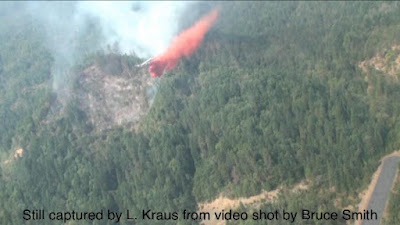
This post finishes up the DC-7 tankers in action series, at least for now.
Continuing with these stills captured by Larry Kraus from video shot by Bruce Smith from the back of the ASM. Here is Larry,


Continuing with these stills captured by Larry Kraus from video shot by Bruce Smith from the back of the ASM. Here is Larry,
This is the last two doors left over from the drop in the previous post. We tried to tie into the beginning of that drop to back it up the hill a little.


DC-7 Tankers in Action: part 5a (Mud Mountain Fire)
Here are some more stills stills, captured by Larry Kraus from video shot by Bruce Smith from the back of the ASM. These stills and the ones in part 5b, are a fire identified as the Mud Mountain Fire. Larry says,


As you can see, we had to drop going down the fireline and downhill with rising terrain after the drop requiring a left turn to flatter terrain in this case.


Wednesday, March 10, 2010
DC-Tankers in Action (part 4)
Continuing with the Dixie Gulch Fire, these stills are captured by Larry Kraus from video shot by Bruce Smith (Air Attack) from the back of the ASM assigned to the fire. According to Larry, the drop shown in this series of stills is the same drop as shown in the you tube video that I posted on March 4 and again on March 5.
With this article, I finish with the Dixie Gulch Fire. I will be finish this series on DC-7 Tankers in Action with my next post.


With this article, I finish with the Dixie Gulch Fire. I will be finish this series on DC-7 Tankers in Action with my next post.


Monday, March 08, 2010
DC-7 Tankers in Action (part 3C)
I conclude this set of three posts of tanker 66 at Dixie Gulch with two stills taken after the drop in the previous article (part 3B). Recall that these stills were captured by Larry Kraus from video shot by Bruce Smith.
Larry wanted you to see these because they show the little airport's (Springbrook) location in relation to the fire. Larry sent along the image from Google Earth where he circled the location of the Dixie Gulch fire shown in the you tube video that I posted on March 5.


Larry wanted you to see these because they show the little airport's (Springbrook) location in relation to the fire. Larry sent along the image from Google Earth where he circled the location of the Dixie Gulch fire shown in the you tube video that I posted on March 5.


DC-7 Tankers in Action (part 3B)


DC-7 Tankers in Action (part 3A)
I continue with these articles on DC-7 tankers in action, focusing on the youtube video (from the Dixie Gulch Fire) that I posted on March 4 and again on March 5. I continue today with three posts (part 3A, part 3B, and part 3C) with some stills captured by Larry Kraus from video shot by Bruce Smith (Air Attack) from the back of the ASM assigned to the fire.
Larry says that these two pictures show
Note what appears to be the small airport in the second photo.


Larry says that these two pictures show
tanker 66 dropping a couple of doors as the second run with his first load on the Dixie Gulch Fire.
Note what appears to be the small airport in the second photo.


Friday, March 05, 2010
DC-7 Tankers in Action (part 2)
Larry found his logs from the day of the fire in the video that I will share with you in a moment. But first, a word on (DC-7) T-66. The pilot-in command of T-66 is Brian Lash. Now it was Brian's day off on the day of the Dixie Gulch Fire, so the pilot of T-66 that day was Gene Teske flying with Rick Langstrom (Brian's co-pilot).
Here are the pertinent entries from Larry's log for Sunday the 13th:
Took 2 loads to the Dixie Gulch Fire-Near the fire from yesterday-Coverage 8 full load twice-Went well with ASM A4- T66 came in from Redmond for 2 loads (Gene Tesko/Rick Langstrom)-Later T10 (Chris Holm) and T05 (Skip) loaded at Medford for fires by Klamath Falls-First T66 had to move out of loading pit-Later T62 had to move (with Medford Air's tug to Ericson ramp))-Fly T62 for 45 minutes total-
Larry provides some more specific information about how he was flying T-62 during the drop shown in the video. But first, I went to pause and spend a little time with some terminology that Larry will be using. Flaps are on the wings of most aircraft, we'll get to them in a little more detail in a minute. BMEP refers to power settings of the engines. In this case, the tachometers on the DC-7 indicate engine rpm. Larry spent a little time the other day providing some more details on these terms as applies to his DC-7, T-62:
As to BMEP, about the best explanation that I can give is that it gives a real-time accurate indication in the cockpit of the horsepower being developed by the engines.
On the DC-7 the tachometers actually indicate the engine rpm. The reduction gears in the engine nosecase reduce the propeller rpm by a factor of 16:9, so the prop turns at a bit over half of the engine RPM. This is partially because the prop tips become supersonic above these reduced speeds and drastically lose efficiency. If my math works, the prop speed on take-off is 1631 rpm with the engine rpm of 2900. This is still a rather impressive 27 revolutions per second for the prop and 48 for the engine.
Wing flaps allow the wing area and camber (curvature) to be altered to make it more efficient for either high or low speed flight. For take-off, the DC-7 uses 20 degrees of flap. The wing flaps extend aft increasing the wing area and deflect downward at a 20 degree angle to increase the camber of the wing.Once the landing gear has been retracted and the airplane has gained enough altitude to safely allow for any settling resulting from the loss of lift, the flaps are fully retracted to allow an increase in speed.
Larry sent along two pictures of T-62, one with the flaps extended and the other with the flaps retracted.


Larry goes on:
With the flaps retracted (to zero degrees) there is slightly less wing area and the wing has less camber which allow for higher speed mainly due to less drag. For landing or the final part of the drop pattern we end up with the flaps fully extended to 50 degrees. This is a high drag position that helps to control the airplane's speed. With the flaps on the DC-7, the first 20 degrees is all lift, 30 degrees is slightly more lift, but with some additional drag. Above 30 degrees any increases in flap angle are mostly drag.
For those of you who are interested in some more specifics on the flaps of the the DC-7, Larry says that
the flaps on the DC-7 are double slotted flaps, but the upper slots on the DC-7 are just airfoil shaped deflectors that are the full span of the flaps, but only have a chord of about a foot. In the picture of a double slotted flap from how stuff works, the slots are larger than the rest of the flap.
Here are two links that Larry sent me to share for those of you who want more information about how flaps work, one is from Wikipedia and the second is from How Stuff Works.
With this as background, Larry continues with how he is flying T-62 during the drop in the video:
I had full flaps (50 degrees) out during the part of the drop pattern that is in the video. At least I have full flaps until the retardant starts coming out at which time we normally retract the flaps to 20 degrees (the take-off setting) and go to climb power which is 175 BMEP and 2400 RPM for the recovery and climb out.
In the final part of the pattern we usually have 2400 RPM set and are throttled back to as low as 100 BMEP, which is the minimum that we can set without driving the engine with the prop instead of the other way around. Normally, in the drop pattern, we start out with 20 flaps and 2400 RPM and 130-140 BMEP in order to stabilize at around 140 kts. On downwind for the drop we'll go to 30 flaps and 130 BMEP and maintain between 130-140 kts.Somewhere around base for the drop we'll go to full flaps and whatever power is required to maintain 130 kts.
When I start dropping the retardant I'll call for Climb Power and Flaps 20. This allows the airplane to accelerate without losing lift too quickly. If I need to make an immediate turn or clear a ridge or both, we'll go to climb power and leave full flaps until we can afford to have the airplane settle a bit with flap retraction. It all depends on the situation at the time.
Thursday, March 04, 2010
DC-7 tankers in action (part 1)
This is a video that I found on youtube a few weeks ago, I sent Larry Kraus the link and we have been chatting about this video over e-mail. This is the first of three or four articles where, with Larry's help, I spend a little time on what is going in this video.
Before I go any further, as you watch the video you will see a drop by T-66 (also a Butler DC-7 tanker), followed by a drop by Larry in T-62, then a drop by T-66, and finally another drop by T-62. I watched the video a few times and thought that the T-62 footage might be the same drop, so I asked him about this. He says,
I came to the same conclusion on the video showing a single drop for each airplane taken from slightly different camera positions.
Larry spent a little time going through his data and logbooks to identify the fire shown in the video. He sent me the following graphic of a TFR (temporary flight restriction) for a group of fires known as the Queen's Branch Complex, saying"
I attached the TFR map for the Queen's Branch Complex of small lightning caused fires near Medford, Oregon. This might be where the video was shot. The only thing that's confusing to me is that there's no sign in the video of the Alaska ASM that was acting as leadplane, but I suppose that it might have been edited out. If it was edited, that's a shame as it would be even more interesting with the lead.
I will go into some more detail in a later post about how Larry identified that the fire in the video is the Dixie Gulch Fire. For now, take a close look at the TFR graphic, you will see a small airport -- Springbrook -- within the TFR. The Dixie Gulch Fire was located not far from the Springbrook Airport. The key, as Larry told me, is the word
"complex" which indicates several fires being included within the confines of the TFR. The Queen's Branch Fire was the first fire responded to and it's name was used for the TFR.

Larry talks about maneuvering T-62 while making a retardant drop:
As to maneuvering the DC-7 around during drop patterns, there are a few things that must be done. The first is that I have to keep glancing at the airspeed indicator every couple of seconds and my co-pilot (Ron Carpinella in the video) knows to tell me if we get down to 120 kts indicated airspeed if I haven't told him that I was purposely slowing the airplane. Also, the DC-7 has an excellent aerodynamic stall warning in the form of a buffeting that starts in the control yoke at about 5 kts above the stall. If you don't release back pressure or reduce the bank angle when this "nibbling" starts, the whole airplane shakes violently enough to about shake your teeth loose prior to the wing actually stalling.
In the video, I think that you will notice that I keep the nose down during the turns and I'm still about 15 kts above stall speed even after tightening the turn. Part of tanker flying includes leaving yourself an escape route to lower terrain if something starts to go wrong. I try to brief my co-pilot on where that escape route is before we start a run. Of course, it isn't always possible to find good routes to lower terrain, so I keep the best available escape path in mind on all drop runs.
The B-17 was a good trainer for that as you couldn't climb out of most situations and had to plan an escape route that was sometimes a couple of miles long. It also gave me a built in awareness of which way was eventually downhill. For several years in the 1970's, I drove a 1964 VW van with a 40 hp engine. I semi-joked that the VW van and the B-17 were very similar as with either one, you always knew which way was uphill and which way the wind was blowing.
One other item on the video is that the camera angle makes T62 look lower in relation to the terrain that it actually is. That said, we do get low and slow (think 130 kts and 150 ft while loaded) and have to maneuver in tight places close to the ground in areas where the visibility can go to zero for several seconds at a time in smoke. As I've mentioned before,the tanker business is complicated and nothing is ever easy.
I asked him about dropping the nose during his turns, he explains:
As far as keeping the nose down in turns in the DC-7. All of the Douglas 4 (piston) engine transports tend to slow quickly if you let the nose come up with a lot of flap deployed. The approach angle for landing is decidedly nose down in these airplanes and a pilot's natural tendency is to let the nose come back up toward the horizon. You have to learn to fight that tendency when flying these airplanes in either the landing or drop configuration.You are also correct in assuming that keeping the nose down in the turns gives an added buffer against a stall.
We will hear from Larry tomorrow on his drop at this fire. Stay tuned!
Other articles in this series (March 5 to March 12, 2010)
DC-7 Tanker in Action (part 2)
DC-7 Tanker in Action (part 3A)
DC-7 Tanker in Action (part 3B)
DC-7 Tanker in Action (part 3C)
DC-7 Tanker in Action (part 4)
DC-7 Tanker in Action (part 5A), Mud Mountain Fire
DC-7 Tanker in Action (part 5B), Mud Mountain Fire
Wednesday, March 03, 2010
DC-7 air tanker (T-62): working with leadplane/air attack
Larry Kraus, pilot of T-62, and I spent some time chatting over e-mail about how he works with lead planes when flying fires. The situation that we are talking about is when he flies with an ASM (a PC-7) that often functions as a lead plane. When the ASM is functioning as a lead plane, the ASM flies at low altitudes (under 500 ft above ground level) with the goal of scoping out where the tanker can make a safe and effective drop. When the lead plane crew have determined where the drop should be made, that information is communicated to the tanker (in this case T-62). The tanker follows the lead plane in, following their route and makes the drop where indicated by the lead plane.
But the ASM can have a second function, that of air attack. As I understand it, the primary function (but not necessarily the only function), of air attack is to coordinate aircraft over the incident fire. This would include communications with the incident commander on the ground and communication with aircraft working the fire.
I'll let Larry explain the ASM function in a little more detail:
The ASM can function as an Air Attack if there is no other Air Attack available over the fire. When that's the case,the ASM will orbit the fire at 1000 ft or higher between tankers to allow the Air Attack to get a good view of the fire in order to plan and co-ordinate the attack on the fire by all resources. The Air Attack will normally be in radio contact with the Incident Commander (Fire Boss),with Dispatch and the air resources.
It's not unusual for the ASM to go to a fire as an initial attack resource and decide that tankers are not needed and then remain over the fire as Air Attack, even if there are no other air resources (helicopters,for instance) are assigned. In that case, the Air Attack will be talking to the firefighters on the ground and with dispatch.
When a tanker arrives,the ASM functions as a leadplane.It then reverts to Air Attack when the tanker leaves. If there is a full time Air Attack available over the fire, the ASM can still take over and act as Air Attack if the normal Air Attack needs to go in for fuel or relief.
Monday, March 01, 2010
Vote for Wildland Firefighter Foundation NASCAR design

Ramblings of a chief officer has a nice post with graphics and a link where we can vote for a wildland fire themed NASCAR design. I am somewhat embarrassed for not posting this sooner because I know the person who came up with the design. Anyway, as I understand if the design wins, all proceeds will go to the Wildland Firefighter Foundation. To see this post go here, and follow the link in the article.
The voting ends in 13 days, which I believe should be on or about March 13. You can vote once each day.
And while you are at Ramblings of a chief officer's blog, take a moment and look around at his great site!
DC-7 tanker: revisiting ballast, weight and balance, and fuselage stations
Some of you may remember the series on the DC-7 tanker that I wrote last December, with the help and cooperation of Larry Kraus. Recall that Larry has been the pilot-in-command of T-62 for 27 years. One article in that series was an article that I wrote on ballast.
I am writing this article to follow-up on that article on ballast that I wrote last December with some information that Larry sent me in e-mail a few days ago. But first, let me review and summarize weight and balance.
All airplanes, large and small, have weight and balance limits that are set by the manufacturer and periodically checked by airframe and powertrain (A&P) mechanics. It is crucial that all airplanes must be within these weight and balance limits for safe flight. Every airplane has a center of gravity (CG), the point at which the plane is perfectly balanced. If you will, you could suspend the airplane from a string at the CG and the plane will be level. A plane with weight distributed too far forward will result in a nose down condition and if the weight is distributed too far aft (in the rear) will result in a nose up position. Both conditions can have fatal consequences for the crew.
In order to bring the airplane, in our case, the DC-7 tanker within her weight and balance limits, ballast is secured at carefully designated stations, known as fuselage stations. Fuselage stations are measured from a point known as a datum (aka fuselage station zero).
When I wrote the article on ballast as applies to the DC-7 tanker last December, Larry wanted to show you a graphic from one of his DC-7 manuals showing the location of the datum and the fuselage stations in the DC-7 tanker. The problem at the time was that the manual that Larry needed was on a laptop that was comatose at the time, so he was unable to share the fuselage station diagram. The only manual that he had was a Douglas manual for a very early DC-6, showing the datum at a different location. Larry's comatose laptop revived, at least temporarily, a few days ago and Larry sent me a copy of the fuselage station diagram for the DC-7 tanker. You might want to click on the image below to enlarge the image for better viewing.

I'll let Larry explain:
It turns out that I was right about the location of fuselage station zero after all.I was sure that it was the front pressure bulkhead in front of the cockpit.As the radome nose on the DC-7 was an option and was several inches longer than the stock metal nose,I couldn't understand how the end of the nose could be the reference point.The early DC-6 must have been different than the later DC-6 and the DC-7.The DC-6 didn't add weather radar until later in production.The only reference picture that I had without the DC-7 manual was a Douglas manual for a very early DC-6.
Subscribe to:
Posts (Atom)