CAL FIRE (CDF) S2T Tanker 71 working Sawtooth Complex Fire (2006)

Sawtooth Complex Fire (Sept. 2006), San Bernardino County CA. Photo Credit: U.S. Forest Service
Monday, October 31, 2011
Late October snowstorm in the northeast
These two short videos represent what has been happening here in northwest New Jersey and other areas of the northeast and mid-atlantic since Oct. 29. I believe that the first video was shot on Saturday (10/29) sometime during the afternoon or early evening.
In my little corner of NW NJ, we had about five inches of heavy wet snow on Saturday, most of it in the span of about five or six hours during the middle of the day. However, areas just a few miles away got twice as much snow.
I took a drive around my town and near by towns just now. As I drove down my street to get some gas this morning, downed tree limbs were the rule. Peoples yards, including my own, are littered with downed tree limbs. You hope that they don't fall on your house, car, or power lines.
Of course, the trouble comes when limbs or trees fell on power lines. I saw some downed wires a couple of miles from my house, along the side of the road. As I drove to slightly higher and more rural areas, I passed three or four roads that were closed due to downed power lines. Forestry crews have to work with the downed trees before the utility crews can begin to work. Yet, I saw signs of progress. Early yesterday morning, the guy that plowed out my driveway told me that most of the nearest commercial strip was without power. This morning, they were powered. And I saw at least two caravans of utility trucks, and a third was parked at a lunch spot.
I am only writing about my corner of New Jersey. There are similar stories (or worse) from Maryland to Maine.
Saturday, October 29, 2011
Early snow storm in northeast
As many of you by no doubt know, we are having an early snow storm here in the northeast. Hopefully, I'll be posting an article this coming Monday, but if I don't then . . .
Cedar Fire - Oct. 29 2003
In October 2003, the Cedar Fire (fueled by Santa Ana Winds) burned in Southern California, eventually burning 280,278 acres. Firefighter Steven Rucker died on October 29, 2003. Thirteen civilians died, 107 people were injured and over 2,700 buildings (residences, commercial buildings, and out buildings) were destroyed. See the Always Remember Memorial for Steven Rucker (Cedar Fire) for more information.
More videos of the Cedar Fire:
updated on July 18, 2013: one video that I had embedded here of the Cedar Fire is no longer available. :-(
Friday, October 28, 2011
Santa Ana Winds: Cause
Cause:
updated on July 18, 2013: video that I had embedded here on the effects of Santa Anna winds is no longer available. :-(
updated on July 18, 2013: video that I had embedded here on the effects of Santa Anna winds is no longer available. :-(
Wednesday, October 26, 2011
Esperanza Fire: Remembering those who died on 10/26/06
On a day when Santa Ana Winds are blowing in southern California with Red Flag warnings up, I want to pause and remember those who lost their lives fighting the Esperanza Fire in 2006. The Esperanza Fire was fueled by Santa Ana Winds. The fire eventually burned some 40,000 acres destroying 34 homes. Five firefighters died.
Let us pause and remember the five firefighters -- crew of San Bernardino National Forest Engine # 57 -- who died fighting that fire. Four died on the 26th, Pablo Cerda died on Oct. 31:
Capt. Mark Loutzenhizer, 43 of Idyllwild
Jason McKay, 27 of Phelan
Jess McLean, 27 of Beaumont
Pablo Cerda, 23 of Fountain Valley
Daniel Hoover-Najera, 20 of San Jacinto
We won't forgot you and our prayers go out to your family, friends, colleagues, and all those who love you.
Always Remember on the Espreanza Fire and the death of the crew of Engine 57.
Wildland Fire Hotlist Thread on remembering the Esperanza and Cedar Fires.
direct link to A tribute to USFS E57 video
One firefighter (Steven Rucker) died on October 29, 2003 fighting another Santa Ana Wind fueled fire, the Cedar Fire. I'll write more about that fire on October 29.
Monday, October 24, 2011
Santa Ana Winds later this week in Southern CA
This time of year is Santa Anna Wind season in portions of southern California around Los Angeles. This means the possibility of elevated fire danger. So, fire season is still very much in the picture for these areas. As you will see from this article from the Press-Enterpirse, the air attack base at Hemet-Ryan is ready.
In October 2008, I posted a short article on santa ana winds where I linked to a webpage on Santa Ana Winds by Robert Fovell, professor of Atmospheric and Oceanic Sciences at the University of California. He also has a FAQ page on the santa ana winds.
I meant to write more about santa ana winds, but I don't think that I did. So, I'll be working on more articles about the santa ana winds over the next couple of weeks.
The NWS out of Los Angeles and Oxnard California (here is their website) has issued a special weather statement at 3:52 AM PDT on Monday, October 24 for moderate santa ana winds and very low relative humidities for late Wednesday Oct. 24 through Friday October 26. They have an excellent graphic of this wind advisory that may be found here, and I should warn you that this graphic seems to updated regularly. So, don't be surprised if you see a different graphic.
For Los Angeles and Ventura Counties, peak wind gusts in the mountains are expected to be 40 to 50 mph and slightly lower in the valleys (35 to 45 mph).
I'll be keeping on eye on this and if anything of note develops firewise during this expected santa ana wind event, I'll let you know.
Update on Oct. 25, 3:10 PM EDT. I just checked out the NWS - Los Angeles/Oxnard CA webpage and saw a different graphic, dated Oct. 24, 10:24 PM PDT. And perhaps by the time you read this there will be yet another graphic, or perhaps none at all if the santa ana wind event is past.
Here is the special weather statement from the NWS that I referred to earlier:
SPECIAL WEATHER STATEMENT
NATIONAL WEATHER SERVICE LOS ANGELES/OXNARD CA
352 AM PDT MON OCT 24 2011
CAZ034>041-044>046-051>054-059-087-088-547-548-250100-
SAN LUIS OBISPO COUNTY CENTRAL COAST-
SANTA BARBARA COUNTY CENTRAL COAST-SANTA YNEZ VALLEY-
SAN LUIS OBISPO COUNTY INTERIOR VALLEYS-CUYAMA VALLEY-
SANTA BARBARA COUNTY SOUTH COAST-VENTURA COUNTY COAST-
LOS ANGELES COUNTY COAST INCLUDING DOWNTOWN LOS ANGELES-
VENTURA COUNTY INTERIOR VALLEYS-VENTURA COUNTY COASTAL VALLEYS-
SANTA MONICA MOUNTAINS RECREATIONAL AREA-
SAN LUIS OBISPO COUNTY MOUNTAINS-SANTA BARBARA COUNTY MOUNTAINS-
VENTURA COUNTY MOUNTAINS-
LOS ANGELES COUNTY MOUNTAINS EXCLUDING THE SANTA MONICA RANGE-
ANTELOPE VALLEY-CATALINA ISLAND-SANTA CLARITA VALLEY-
LOS ANGELES COUNTY SAN FERNANDO VALLEY-
LOS ANGELES COUNTY SAN GABRIEL VALLEY-
352 AM PDT MON OCT 24 2011
...MODERATE SANTA ANA WINDS WITH VERY LOW HUMIDITIES EXPECTED
LATE WEDNESDAY THROUGH FRIDAY...
HIGH PRESSURE WILL BUILD INTO THE GREAT BASIN ON WEDNESDAY...
RESULTING IN INCREASING OFFSHORE FLOW OVER SOUTHWESTERN CALIFORNIA
FROM WEDNESDAY AFTERNOON THROUGH THURSDAY. GUSTY NORTHEAST CANYON WINDS ARE EXPECTED THROUGH AND BELOW THE FAVORED PASSES AND CANYONS OF VENTURA AND LOS ANGELES COUNTIES...WHERE SOME AREAS MAY HAVE ADVISORY LEVEL WIND GUSTS BETWEEN 40 AND 50 MPH. BY THURSDAY NIGHT AND FRIDAY...OFFSHORE FLOW WILL PERSIST BUT THE NORTHEAST WINDS WILL NOT BE QUITE AS STRONG.
THE OFFSHORE FLOW WILL IMPORT VERY DRY AIR INTO THE REGION AS WELL.
ON WEDNESDAY...AFTERNOON RELATIVE HUMIDITY WILL FALL IN THE LOW
TEENS AND SINGLE DIGITS ACROSS THE MOUNTAINS. THESE LOW RELATIVE
HUMIDITIES WILL THEN SPREAD INTO THE FOOTHILLS AND VALLEYS ON
THURSDAY AND FRIDAY. THE OFFSHORE WINDS WILL RESULT IN VERY POOR
OVERNIGHT RELATIVE HUMIDITY RECOVERY. THE LOW HUMIDITIES COMBINED
WITH GUSTY CANYON WINDS LATE WEDNESDAY THROUGH FRIDAY MORNING WILL
RESULT IN HEIGHTENED FIRE WEATHER CONCERNS. THERE WILL BE THE
POTENTIAL FOR RED FLAG CONDITIONS DURING THE PERIOD...ESPECIALLY
FOR THE MOUNTAINS OF VENTURA AND LOS ANGELES COUNTIES INCLUDING
THE SANTA MONICA RANGE...AND THE SANTA CLARITA VALLEY. A FIRE
WEATHER WATCH MAY EVENTUALLY BE NEEDED FOR THESE AREAS AS WE
DRAW CLOSER TO THE EVENT.
AS THE OFFSHORE FLOW DEVELOPS...A WARMING TREND CAN BE EXPECTED
WEDNESDAY THROUGH FRIDAY...BUT HOT CONDITIONS ARE NOT ANTICIPATED.
THE MOST NOTICEABLE WARMING WILL OCCUR ON THURSDAY AND FRIDAY WITH
MANY COASTAL AND VALLEY AREAS IN THE UPPER 70S TO MID 80S.
STAY TUNED TO NOAA WEATHER RADIO OR YOUR LOCAL MEDIA FOR THE
LATEST UPDATES ON THIS SITUATION.
Friday, October 21, 2011
1991 Oakland Hills Fire
I was on the wildlandfire hotlist forums this morning when I came across this thread on the 1991 Oakland Hills Fires that burned from Oct. 19 to Oct. 22, 2001. I was curious so I followed the links referred to in that hotlist forum thread. The first one is from the the Mercury Newst about a photographer, Richard Misrach. who witnessed and then photographed the fire.
In addition there was a link to Always Remember where I learned more about this fire. I learned that the fire destroyed 3,354 structures, 790 in one hour on a Sunday morning after the fire went out of control. The fire started later in the day on a Saturday, by later Saturday evening the blaze was confined to five acres and was to be mopped up on Sunday morning. Only Sunday morning came with Red Flag conditions and high winds. During mop-up, a spark got away in the winds and the fire was out of control by about 11:15 AM. By noon, 790 homes were destroyed. You will want to read the Always Remember article and follow the links at the bottom of that page to view some photos of the fire.
Twenty-five people died including at least two responders.
I'd like to thank the webmaster of the NJFFS Section B10 website for embedded the video. When I watched the video, the final piece to today's article fell in place.
I am glad that my wonderings on the web this morning brought this catastrophic fire to my attention. At the time of the fire, I believe that I was completely immersed in some graduate school exams. So it is entirely possible that I knew nothing about this fire. I do know, and am stunned by the amount of damage done.
Wednesday, October 19, 2011
Update on wildfires in the eastern U.S.
Honey Prairie Fire (GA/FL)
The Honey Prairie Fire continues in the Okefenokee National Wildlife Refuge. According to the latest inciweb information available at the time I write this article (October 14), the fire continues to creep and smolder, advancing on the order of one-quarter of mile since the middle of September. The acreage burned stands at 309,173 acres with 72 people working the fire, and it is 76% contained. The Refuge is open.
The Pagami Creek Fire in the Superior National Forest and near the Boundary Waters Canoe Wilderness Area (BWCWA) continues to burn. Areas previously closed in the Superior National Forest and the BWCWA are open. According to the latest report from Inciweb, the fire has burned 92,682 acres and is at 91% containment.
Lateral Fire, Great Dismal Swamp National Wildlife Refuge (VA)
In my wonderings on the internet in September, I saw a news report somewhere that a fire in the Great Dismal Swamp National Wildlife Refuge was continuing to burn even after receiving several inches of rain. Unfortunately, I did not make a note of that news report. But I kept my eyes open, and saw this Washington Post article on the fire, reporting on the fact that it still burns in spite of receiving heavy rains in prior weeks.
According to the latest inciweb report, this fire (known as the Lateral Fire) has burned 6,577 acres and is 90% contained. It is burning on the ground in peat fuels.
The Honey Prairie Fire continues in the Okefenokee National Wildlife Refuge. According to the latest inciweb information available at the time I write this article (October 14), the fire continues to creep and smolder, advancing on the order of one-quarter of mile since the middle of September. The acreage burned stands at 309,173 acres with 72 people working the fire, and it is 76% contained. The Refuge is open.
- Inciweb on Honey Prairie Fire
- Okefenokee National Wildlife Refuge Page on the Honey Prairie Fire
- Okefenokee National Wildlife Refuge on Facebook (public)
The Pagami Creek Fire in the Superior National Forest and near the Boundary Waters Canoe Wilderness Area (BWCWA) continues to burn. Areas previously closed in the Superior National Forest and the BWCWA are open. According to the latest report from Inciweb, the fire has burned 92,682 acres and is at 91% containment.
Lateral Fire, Great Dismal Swamp National Wildlife Refuge (VA)
In my wonderings on the internet in September, I saw a news report somewhere that a fire in the Great Dismal Swamp National Wildlife Refuge was continuing to burn even after receiving several inches of rain. Unfortunately, I did not make a note of that news report. But I kept my eyes open, and saw this Washington Post article on the fire, reporting on the fact that it still burns in spite of receiving heavy rains in prior weeks.
According to the latest inciweb report, this fire (known as the Lateral Fire) has burned 6,577 acres and is 90% contained. It is burning on the ground in peat fuels.
Monday, October 17, 2011
TBM Avenger Tanker 13 (Bu# 53200, N9101C, CGLEL)
Last Friday, I wrote that TBM Avenger Tanker #13 arrived in the Museum of Mountain Flying in Missoula, MT. I continue with a brief history of TBM Avenger #13.
1945: Construction number # 3262
1945-52: US Navy Bureau # 53200
1952-58: Royal Canadian Navy #377
1958-69: Hillcrest Aviation, Lewiston, ID. N9101C. Flew as airtanker, #D6
1969-72: Johnson Flying Service, Missoula, MT. Flew as airtanker #A13
Late 1974: sold to Forest Protection Limited, New Brunswick, CA.
1975-2010: Forest Protection Limited (FPL), A13, 13
1975-93: aerial spray (Budworm, etc)
1993-4, 1996: fire suppression (spare)
1995, 1997-2010: Fire suppression
References for history of TBM Avenger #13
The Warbird Registry's page on TBM Avenger Bureau # 52300 may be found here.
There is a nice website with information archives for TBM Avengers and Forest Protection Limited that may be found here. There is a lot of history here relating to FPL's Avengers as well as TBM's from the U.S. and other Canadian operators used for budworm spraying operations in New Brunswick. You could spend hours on this site. These TBM Avenger/FPL information archives has a nice page devoted to C-GLEL, #13 with her history, names of pilots who flew her, and pictures. Please spend some time on this page to get to know #13.
The video embedded below shows FPL TBM Avenger #24, a sister tanker to #13. Here is a picture of FPL's fleet of air tankers in 2001 , including #13 and #24.:
I have grown to love #13 through spending a couple of hours on the TBM Avenger/FPL information archives. I expect that the folk at FPL and in Fredericton New Brunswick are very sad to her go. I hope that they can take some consolation that many in Missoula, MT are overjoyed to have her at the Museum of Mountain Flying. She is loved by many in Missoula and will be loved by many, many more.
Friday, October 14, 2011
A bit of aerial firefighting history: TBM Avenger air tanker arrives in Missoula
The other day, I read with interest Bill Gabbert's (of Wildfire Today) article on new and old tankers. He wrote about a drop that Neptune Aviation's new jet tanker, T-40 made on a fire in Texas, including a picture. But, it was his reporting on TBM Avenger Air Tanker (T-13) arrival at the Museum of Mountain Flying in Missoula Montana on Oct. 10 that caught my eye. Bill referenced two articles from the Missoulian, one on Oct. 8 and another on Oct. 10, at the same time a friend of mine referred me to the Oct. 10 Missoulian article. The byline on both articles is Kim Briggeman.
Simply, the Museum of Mountain Flying was able to secure funding to purchase TBM Avenger T-13, from Forest Protection Limited. She arrived with great fanfare in Missoula on Oct. 10 after a three day flight from New Brunswick, Canada.
I went and read the articles on the Missoulian website, and I hope you will too. Reading the article, I found out that T-13 was a part of Johnson Flying Service's fleet of tankers, flying as tanker A-13. You can read about this history of Missoulia International Airport operations including the Johnson Flying Service here. Johnson Flying Service was based in Missoula and sold A-13 along with five other Avengers to Forest Protection Limited of New Brunswick, Canada in 1974 where she flew as a fire bomber and spraying insects.
Among the interesting pieces of "trivia" that I learned from the Oct. 10th article was that Johnson's six Avengers did spraying in Maine in 1973. This interested me because I used to spend summer vacations camping on the Maine coast as a youth in the 1960s through 1970 and again a couple of trips to the same camping spot in the late 1970s. I had this idea as a youth that airplanes were used to spray for insects. I have no clue where the Avengers sprayed in 1973, perhaps they sprayed in the northern Maine forests. I have no clue if the Avengers sprayed on the Maine coast (for Mosquitos??). But, where ever they were, I rather enjoy the image of these Avengers spraying in Maine in 1973. I wasn't in Maine that summer, but that doesn't seem to matter.
What came across to me through reading the reporting of Kim Briggeman in the Missoulian is that "A-13" is loved in Missoula. I feel a sort of bond with "A-13" and the other Johnson TBMs because they flew in Maine at least one summer.
But I also know that "A-13" flew for Forest Protection Limited (FPL) for thirty plus years under registration number C-GLEL, tanker 13. In my article on October 17, I'll write more about her history including her military service and her years with FPL. Stay tuned
Wednesday, October 12, 2011
New Jersey Forest Fire Service Ops during and after Irene
The New Jersey Forest Fire Service (NJFFS) does more than fight wildfires. The aftermath of Hurricane Irene provided but one example of non-fire related emergencies that the NJFFS are involved with. The following list may not include all the assistance provided by the NJFFS in the aftermath of Hurricane Irene. And it does not reflect any NJFFS assistance provided in the aftermath of Tropical Storm Lee and other heavy rain events in September.
Assisted in rescuing approximately 30 senior citizens and their pets from mobile homes in Buena Vista.
Deployed 6x6 high wheeled trucks to various Counties around the State at various time after Irene including but not limited to Morris, Passaic, Cape May and Salem Counties. The crew in these trucks assisted with various emergency duties including but not limited to evacuations from flooded residential areas.
Deployed a saw team to Egg Harbor Twsp to assist in tree removal from roads.
Water buffalos (a kind of water tank on wheels) were deployed to West Milford in northern Passaic County.
Bull dozers and backhoes crewed by the NJFFS assisted with road repair in Stokes State Forest (Sussex County).
NJFFFS saw crews along with crews in bull dozers and back hoes repaired roads and removed trees and debris in Alliare State Park and Monmouth Battlefield (Monmouth County)
Saw crews assisted with tree removal in Delaware and Raritan Canal State Park (Hunterdon, Mercer counties).
For more information see this thread on the wildland fire hotlist.
Kudos to the NJFFS! Thank-you.
Monday, October 10, 2011
Tribute to Aero Union
An awesome tribute to Aero Union by the Envenomator1. Please go here and click on more to read what he has to say.
To all my friends at Aero Union, you are not forgotten.
Friday, October 07, 2011
CL-415 (turbo) scooper
I've got a couple of projects in the pipeline for future blog articles. In the meantime, I found this nice video on the Canadian built Bombardier CL-415 scooper. The CL-415 is purpose built fire bomber. It is an amphibious aircraft that "scoops" water out of a water body for eventual dropping on a fire. Originally built by Canadair , the CL-415 evolved from the CL-215 (also an amphibious aircraft. The original CL-215 had piston engines. Canadair started out by modifying some CL-215 airframes by, among other things, adding turbo props and calling them CL-215T's, Eventually, they built new airframes with turbo prop engines with the designation, CL-415. For more on the CL-415 see:
wikipedia on CL 415
Bombardier super scooper page
Two or three CL-215's had been flying fires in the U.S. during the later portion of the summer and possibly into September. I'm not quite sure if they are still in the U.S. at the moment. According to altadena (CA) online, the CL-415s will be in LA County through Nov. 31, 2011.
According to a Sept. 6, 2011 post on smokeshowin (article no longer available online), the Quebec Government-owned CL-415s (Tankers #240 and #241) are based out of Van Nuys airport and had already worked two fires. This is the eighteenth year that LA County has contracted with Quebec for two CL-415s.
Thank-you Canada!
update on Oct. 7, 2011 9:39 AM EDT: A good friend told me that the video that I embedded yesterday may have been of a model. Further, some of the maneuvers that were done are not maneuvers that occur on normal fire bombing runs. While the vide is fun to watch and nicely done, I wanted to show a CL 415 fire bomber. So, I went to you tube and found the video that I embedded here, honoring the men and women of the Ontario Ministry of Natural Resources aviation and forest fire management program.
Wednesday, October 05, 2011
Other wildfire aerial tactical operations
I have found myself thinking a lot about other wildfire aerial tactical operations recently. By these other operations, I am thinking about aerial tactical operations that may also be referred to as aerial supervision operations. In the video that I embedded here you are seeing one such type of aerial supervision, that of a lead plane leading in a tanker on a retardant drop. For the record, I am aware that the job of a lead plane pilot involves a lot more than what you are seeing in this video. I am hoping to write an article or two later this fall or early this winter devoted to lead planes.
There are also air tactical group supervisors (ATGS )who I believe manage the air space and air traffic over a fire.
In an Aerial Supervision Module, a crew of two is in an aircraft over the fire. The air tactical pilot who may also be a lead plane pilot flies the plane. The second person as an ATGS.
The Aerial Supervision Guide (NWCG) goes into a lot of detail about lead planes, ATGS, ASMs, and other air tactical operations.
CAL FIRE uses OV-10A's for their air tactical operations to supervise aircraft on wildfires working with the incident commander on the ground. The OV-10's have a crew of two, the pilot and a supervisor. As I understand it, the crew does not lead the tankers into a drop, but they do tell the CAL FIRE tankers and helps where to make their retardant drops.
The Canadians call their two-person air tactical planes birddogs. Some states use observation aircraft. There is a nice, short description of Conair's (Abbostford, BC) here., along with some nice photos of the Conair's fleet of A-26 tankers now retired from service).
All these operations deserve much more time than I can devote at this time. As I said earlier, I hope to write more about lead planes in a few weeks. At that time, I also hope to write about Aerial Supervision Modules, Birddogs, CAL FIRE's air tactical operations, and other operations that I have not listed here (including helo supervision) Until I do, please remember that there are often aerial tactical operations in place over a wildfire.
I am reminded of a phrase that I have used here before, something that Larry Kraus pilot of Bulter's T-62 told me when we were corresponding about T-62:
"see I told you that the tanker business is complicated"
So I'll add, the business of air tactical operations over wildfires are complicated.
To all who are crew of tactical aircraft working wildfires, I know that you are there. Thank-you.
Monday, October 03, 2011
Fire and fuel breaks in NJ's wildland urban inerface
I recently had the opportunity to learn a little about fire management practices in the wildland urban interface in the pinelands in central and southern NJ through attending a day long Forest Stewardship Firewise Tour. One of the fire management practices that I learned about that day are fire and fuel breaks. I got a handout that morning: Wildfire: Best management practices for creating and maintaing wildfire fuelbreaks in New Jersey's Wildland Urban Interface (WUI) is available on the NJ Forest Fire Service's website at this location (a pdf file). This document starts with some definitions, some that I will include here and then moves on to a discussion of what the individual homeowner living in the WUI can do.
Further, fire and fuel breaks are also built and maintained along natural or constructed "roads" through the WUI. In February of 2010, I wrote about firebreaks that were planned for Barnegat NJ, go here to see that article. I had a chance to visit one such fire and fuel break in Stafford Township, NJ within the burn area of 15,000 acre 2007 Warren Grove fire. To be honest, I'm not quite sure if this was the firebreak that I wrote about in February 2010, but I don't think that really matters.
I'll start with briefly summarizing some definitions from the document I referred to earlier, Wildfire: Best management practices for creating and maintaing wildfire fuelbreaks in New Jersey's Wildland Urban Interface (WUI) :
Firebreak: A natural or constructed barrier used to stop or check fires
that occur, or to provide a control line from which to work.
Fuelbreak: A natural or manmade change in fuel characteristics that
affect fire behavior so that fires burning into them can be more readily
controlled and managed.
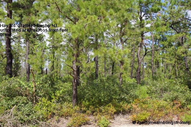
Keeping these definitions in mind, I had a chance to visit the Hay Rd. fire and fuel break in Stafford Township, NJ within the burn area of the 2007 Warren Grove fire.
Here are some pictures that I took that day. Hay Rd. itself is the firebreak. The fuel break is on one side of the road. Hay Rd. is a sand road a little to the north west of the Stafford Township Recycling Center, that may be found on this image from wikimapia.


Other relevant links of interest from the NJ Forest Fire Service website:
Wildfire hazard mitigation
Prescribed burning
Fire planning (including links at bottom of page)
Fire hazard regulations
Definitions
Further, fire and fuel breaks are also built and maintained along natural or constructed "roads" through the WUI. In February of 2010, I wrote about firebreaks that were planned for Barnegat NJ, go here to see that article. I had a chance to visit one such fire and fuel break in Stafford Township, NJ within the burn area of 15,000 acre 2007 Warren Grove fire. To be honest, I'm not quite sure if this was the firebreak that I wrote about in February 2010, but I don't think that really matters.
I'll start with briefly summarizing some definitions from the document I referred to earlier, Wildfire: Best management practices for creating and maintaing wildfire fuelbreaks in New Jersey's Wildland Urban Interface (WUI) :
Firebreak: A natural or constructed barrier used to stop or check fires
that occur, or to provide a control line from which to work.
Fuelbreak: A natural or manmade change in fuel characteristics that
affect fire behavior so that fires burning into them can be more readily
controlled and managed.
Keeping these definitions in mind, I had a chance to visit the Hay Rd. fire and fuel break in Stafford Township, NJ within the burn area of the 2007 Warren Grove fire.
Here are some pictures that I took that day. Hay Rd. itself is the firebreak. The fuel break is on one side of the road. Hay Rd. is a sand road a little to the north west of the Stafford Township Recycling Center, that may be found on this image from wikimapia.


Other relevant links of interest from the NJ Forest Fire Service website:
Wildfire hazard mitigation
Prescribed burning
Fire planning (including links at bottom of page)
Fire hazard regulations
Definitions
Saturday, October 01, 2011
Subscribe to:
Posts (Atom)