Showing posts with label Delaware River. Show all posts

Thursday, October 09, 2008

Delaware River (part 3): a culvert along the canal

I took a drive down to check out a section of the Delaware and Raritan Canal about two miles south of Lambertville, NJ yesterday afternoon. I wanted to check out some markers that I first saw when I went to that section of the canal last March. The markers, near a culvert, turned out to be uninteresting.

But I was interested in the culvert, so I am attaching two photos of the culvert, one from each side of the culvert. When I went back yesterday, I was struck by the much lower level of the Delaware River as compared with March 6, 2008 (bankfull). I am including two pictures looking from the towpath along the canal at the culvert looking towards the Delaware River. One, taken in March, shows the River at bankfull. The other, taken yesterday from about the same spot, shows the River at a significantly lower level, probably more along the lines of a "normal" level if not a tad on the low side.


Tuesday, October 07, 2008

Delaware River (March 2008): part 2

Both pictures were taken in Lambertville. One was taken on March 6, 2008 when the Delaware was at bankfull and the second was taken nine days later on March 15. I tried to go to the same spot on March 15 from which I had taken the earlier photo, but you can see that I was off a little. Nevertheless, I think you get the idea.


Monday, October 06, 2008

Delaware River (March 2008): part 1

Last March (March 6) I was out for a walk along the Delaware River when the River was at what is known as bankfull. We had just had a significant amount of rain and there was the possibility of even more rain a couple of days later. Bankfull is as what you think. This is when a river or stream is near the top of its bank, just shy of flood stage. Residents in floodprone towns including but not limited to Frenchtown and Lambertville prepared for the floods by sandbagging vulnerable areas.

So, if the substantial rainfall that was predicted a couple of days later, the river would flood for (I think) the fourth time in four years. The predicted significant rainfall did not materialize, fortunately.

By March 15, the river was back down. I drove down with my friend to get some pictures of the River at more normal levels to provide a contrast with the pictures I got on March 6 when the River was at bankfull. We saw the sandbags that I photographed, in either Lambertville or Frenchtown. I got these shots. I was interested in the culvert which may have been the source of flooding in the adjacent parking lot.

I'll post the before and after pictures tomorrow.


Saturday, September 13, 2008

Trees in Delaware River floodplain near Frenchtown NJ

I wrote a few days about my walk along the Delaware River south of Frenchtown NJ along the Delaware and Raritan Canal Towpath. Now I am not a Forester or otherwise an expert at tree identification, I am an amateur at this. And I have books that I use to help me. In particular, I found this book in our home library a few days ago:

Collins, Reryl Robichaud and Karl H. Anderson. 1994. Plant Communities of New Jersey: A study in Diversity. New Brunswick NJ: Rutgers University Press.


They have a chapter on freshwater wetlands in northern New Jersey. While not specifically describing the Delaware River floodplains, perhaps because it forms the western border of NJ and PA, they do describe the floodplains of a river that is in the same physiographic region of NJ. Broadly speaking there are four physiographic regions in New Jersey, the portion of the Delaware River that I visit and the town I live in are in the piedmont region.

Collins and Anderson describe the plants located in the floodplain of the Raritan River in the piedmont regions. Two of the trees that they say are found in these floodplains are the River Birch, and the Sycamore. The links that I have provided are from a wetlands plants database from the U.S. Department of Agriculture. They have a web interface that allows you to narrow your search of wetlands plants to your specific state and by plant type. If you are so inclined, check out the information provided on each of the links I provided for River Birches and Sycamores.

Speaking of Sycamores, I got to know Sycamores because they were numerous Sycamore trees located in the Hundson County town where we used to live. They line many of the residential streets in this town, and are also located in the parks, including the green area along the Passaic River.

I wrote about these two trees, because these were the common trees located in the region between the towpath that we were walking on and the Delaware River. Other trees that we saw were species of Maple and Oak, Hickory and/or Ash and Sweet Gum.

A word about Hickory and Ash. Both have what are known as compound leaflets (5 to 9 leaves). For more information on leaf terminology, see this webpage. There is an important but perhaps subtle difference between the leaf structure of Hickories and Ashes. I'm not sure that I can explain this in any way that will make sense. You will have to trust me that this difference can make it sometimes difficult to distinguish between Ash and Hickories, at least for me. Any tree guide, I have several tree guides including some very good guides put out by the Audubon Society, will have a chapter where they discuss various leaf types and other basic terminology used to identify trees.

Anyway, it was hard for me to distinguish between Ash and Hickory because the foiliage was too high for me to distinguish between the leaf structures of Ashes v Hickories. As for identifying trees by their bark, I am getting better, but it is still hard, sometimes requiring more study. Having read up on Ash and Hickories on my tree guides, when we go back, I may be better able to distinguish between the two.

Tuesday, September 09, 2008

Walking along the Delaware River

We are frequent visitors to the Delaware River in Hunterdon County, NJ. Usually someowhere between Frenchtown and Washington's Crossing. We pick a spot, park our car and walk for an hour or more usually along the Delaware and Raritan Canal. We share the path with bicyclists and the occasional jogger.

Given how much I love trees, I have been bothered that I have not been paying much mind to the trees that we pass. So, this week I paid attention to the trees as we walked. Given that this area is in a floodplain along a major river in the Piedmont section of northern New Jersey, I had an idea of what to find. And later ran through my list cross checking it with my Audubon tree guides and a book I have on NJ Plant Communities.

I would not call myself an expert at tree identification. When most of the tree is tall and most of the foliage is upwards of twenty feet or more high, it is sometimes hard for me to identify a tree off of the leaf structure. But between my friend and I, we at least have a good idea of some of the major trees that we saw on this walk. I'll write about these later, with links to pictures and the like.

I wish I was brave enough to wonder through the undergrowth between the canal path and the River to poke and get a closer look at the trees. However, the thick undergrowth of poison ivy discouraged me. And I was wearing shorts.

So, stay tuned . . .

Monday, September 25, 2006

Delaware River Redux

Ok, one last post on the subject of the June 2006 Delaware River Floods. I was talking to a friend a few days ago who was years and years of experience in hydrology and water utilities management, the subject turned to floods so I brought up the Delaware River floods. In case you are wondering, hydrology, according to Websters, is a science dealing with the properties, distribution, and circulation of water on and below the earth's surface and in the atmosphere.

For awhile know I have been wondering if, instead of the State coming along and offering to "buy out" certain residential properties in flood prone areas, why couldn't the Government offer direct subsidies to help offset at least some of the costs of rehabbing the property to better with stand flooding. For example, putting a house on piers, raising outlets so that they are a three feet higher, suspending the furnace from the ceiling, and taking appliances including hot water heaters out of the basement or first floor, to name a few.

Well, I'm glad I talked to my friend, because he told me something which seemed very simple. That is, that it is not always possible to rehabs so a house will withstand flooding with minimal problems. I was reminded of all the times that people ask me about my "summer cabin" or camp in Vermont. It was not built to be lived in from mid-October to early-May. People are always asking me, why don't you have the house "winterized"? I reply that it is literally impossible to add insulation and otherwise seal off the house to keep it warm. First it is built on short piers, there is no basement, and no place for insulation. It just can't be done. I would be better off tearing the house down and building a new house.

So, I am back to square one. I have thiis idea in my head that I have to acknowledge may not work. I continue to think about all those people living along the Delaware who love the River and want to keep living there. Some are going to have the money, from various sources, to do the type of rehabbing that I am talking about. Just as important, they have a house that can be rehabbed. What happens to the people who can not afford to rehabb their house so that it can withstand floods. What happens to the people who own a house that can not be rehabbed?

No answers, I'm afraid. Just questions.

Thursday, August 10, 2006

Update on Lambertville-New Hope Bridge

On July 6, 2006, The Hunterdon Democrat reported on an engineer’s inspection of the Lambertville–New Hope bridge. The lowest visible portion of the bridge deck of the Lambertville–New Hope Bridge suffered some minor damage in the form of “slight denting.” None of the piers were damaged. The bridge passed weight–bearing load tests. Repairs will be necessary, and the Hunterdon Democrat is reporting that the engineers are saying that bridge is safe for vehicular traffic.

The assumption being that this was the result of damage from floating debris. This bridge, like the other crossings, were inspected prior to reopening to be sure that both the bridge and the roads were safe to reopen. The Hunterdon Democrat did make two interesting points in regards to the Lambertville–New Hope Bridge. One is that Emergency responders are encouraged to use the toll bridge (a couple of miles north) when possible. The second point is that guards are on duty 24 hours a day to enforce weight limits.

This bridge is known by locals as “the free bridge” when compared to the toll bridge where U.S. Highway 202 crosses the Delaware River about two miles north of the free bridge. For those of you who are not familiar with these two rivertowns, the free bridge connects the shopping/restaurant districts of Lambertville, NJ and New Hope, PA. Any longer–term closing of the free bridge has the potential to severely impact businesses in both towns.

I was interested in the fact the Hunterdon Democrat made a point of saying that guards are on duty 24 hours to enforce weight limits. Is this the normal course of operations for the bridge? I can only hope so. Weight limits should be enforced at all times, not just after a flood when the bridge sustained some minor damage.

I am sure that the Hunterdon Democrat will report on the status of these repairs if they are deemed newsworthy. This should be easy for me to do because I get the Hunterdon Democrat delivered to my home. I will monitor the local press over the coming weeks and months and report back here if anything interesting happens.

Wednesday, August 02, 2006

awesome videos of floods in Frenchtown NJ

Frenchtown is about ten miles north of Lambertville NJ on the Delaware. In one of my earlier posts, I posted a link to some photos posted on the website of Emergency Management Services of Hunterdon County. For those of you who haven't visited this site in the past couple of weeks, I urge you to go back to the Hunterdon County EMS site to see some really awesome videos taken by Donna and Bill Knispel of Frenchtown NJ.

Speaking of debris, this video clip taken by the Knispels shows a rather large tree floating down the River.

I was able to view these video clips on my Mac with Quicktime. I don't know what you PC folk use to see videos on the web. I'd imagine that one of your windows programs will do fine.

Another picture of floods in Lambertville NJ

At the time that I made my entry, floods part 3 on July 7, on the Delaware River floods of June 29, I was not able to find a picture of the parking lot at the Lambertville Station in Lambertville where I took my photographs. I thought that it might be interesting to post a link to a picture. Well, I finally was able to spend some time on the website of the Delaware River Basin Commission (DRBC) . They have a webpage with links to variety of information on the June 2006 floods . I have downloaded some documents from that website that I am in the process of reading. When I am finished reading these documents, I will post my thoughts and impressions here.

When I got to the DRBC June 2006 flood page, I scrolled down to the link for photographs and found this photograph . Note that the floodwaters go almost up to the top of the arches on the “first floor” of the inn at Lambertville Station. Pretty impressive. The place where I was standing to take the photographs of the Lambertville-New Hope Bridge was probably in about eight feet of water. At least this is my guesstimate.

Speaking of the bridge, I read in one of the local papers recently that there was a possibility that there was some damage from debris to the bridge in the River. I have to say that having seen the river a day after both the June 2006 floods and the April 2005 floods, that I saw some pretty impressive trees floating in the River. Really big trees. So, I am not surprised about the possibility of damage to the bridge. This to is something that I want to follow-up on and will write about here. Speaking of debris, apparently one of the issues that the folk in the towns along the River (and others) is the issue of debris in the creeks that flow into the River. There is a creek a couple of blocks south of the Lambertville Station called the Swan Creek. The Swan Creek flooded, and if there is any debris in the creek from either the Sept. 2004 or the April 2005 floods, then I can only imagine that this could of made the Swan Creek flooding worse.

We went for a walk this past Sunday, about 2 miles north on the canal that is about one city block in from the River. We passed two places where there were bridge abutments, sorry no pictures yet (to be honest, I was so hot, I couldn’t deal with standing in the sun to take pictures). The first was when an old railroad crossed the canal on elevated track. The second was another bridge where some sort of creek with a small waterfall met the canal. At both bridges, I saw a large amount of what I call tree litter, branches of various sizes. When it cools down a little, I am going to go back and take some pictures. Again, stay tuned.


In closing, one picture I did take last Sunday was a picture of the Lambertville-New Hope Bridge. This picture shows the River at more or less “normal” level. If you look closely, you will see a little bit of dirt around the bridge abutments. If you go back to my July 7 entry, you won't see any dirt around the bridge abutments.

Friday, July 07, 2006

Floods part 3

The pictures that I am posting here were talking last Saturday (July 1) from Lambertville NJ. The river was well below flood stage by this time, but was still running a little high. I could tell because some of the trees on the banks were partially submerged. These are trees that are normally completely out of the water.

The Hunterdon County Office of Emergency Management has information on flood levels. You may need to scroll down a little to see the chart. To put this in context, flood stage of the Delaware River at New Hope, PA is 13 feet. New Hope is across the River from Lambertville. I got the information from the weather service, in case you want to check it out. According to Hunterdon County EMS, the River crested at 19.5 feet, the same level as the 2005 floods and below the 24.7 feet recorded from the 1955 floods. I may have said in an earlier post that the 1955 floods, from two back to back hurricanes, seem to be the one that all others are compared to.

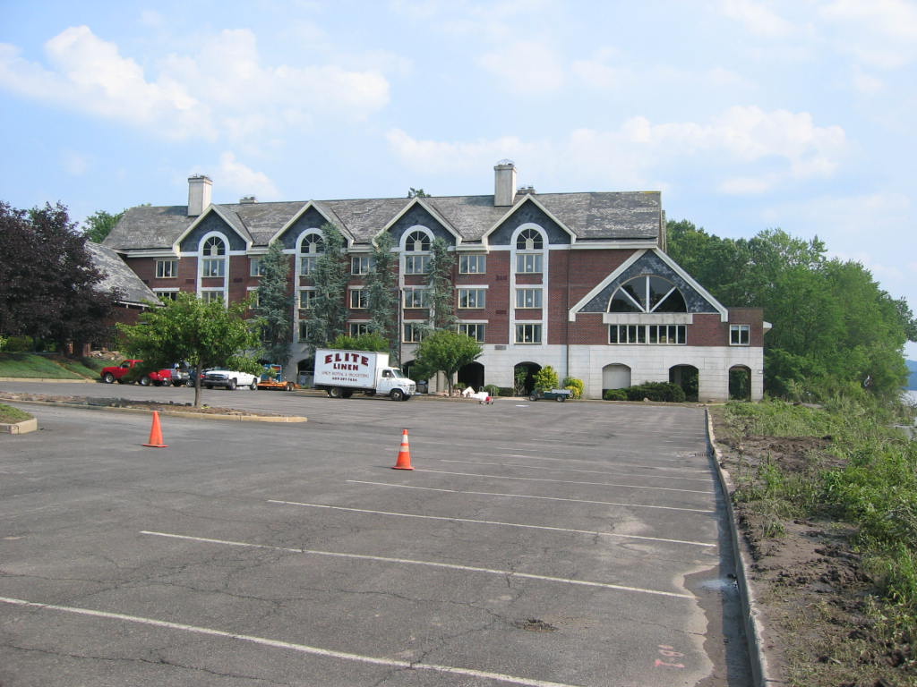
In Lambertville, there is an Inn, and a restaurant next to the River, Lambertville Station. The parking lot is next to the river.


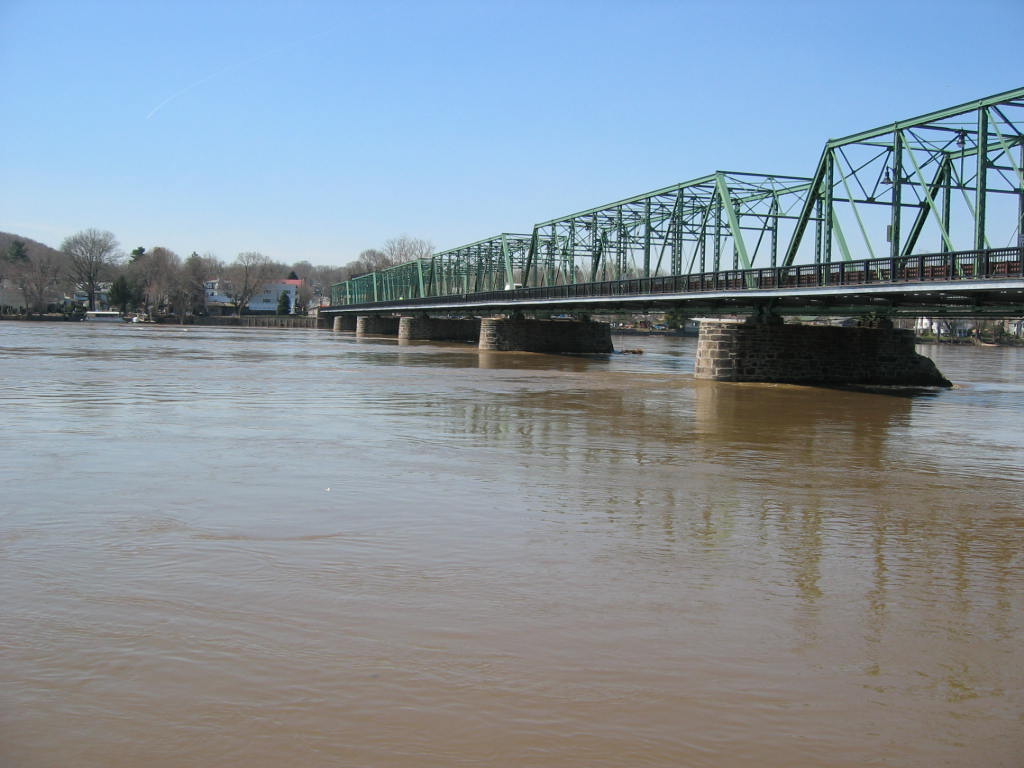
Note the arches on the building in the Inn in the photo. According to some footage I saw on the local news a good bit of those arches were under water during the flood. The rooms on the "first floor" are above the arches and, were not flooded (as far as I know). By the way, the restaurant is in a separate building a short distance from the Inn, fronting on Bridge St. Bridge St, as its name implies leads to what the locals refer to as the "free bridge" to New Hope. The picture of the bridge was taken a couple of days after the April 2005 floods, so the River was still high. This was the only photo taken after the April 2005 floods, all the others were taken on July 1. 2006.
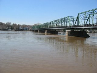


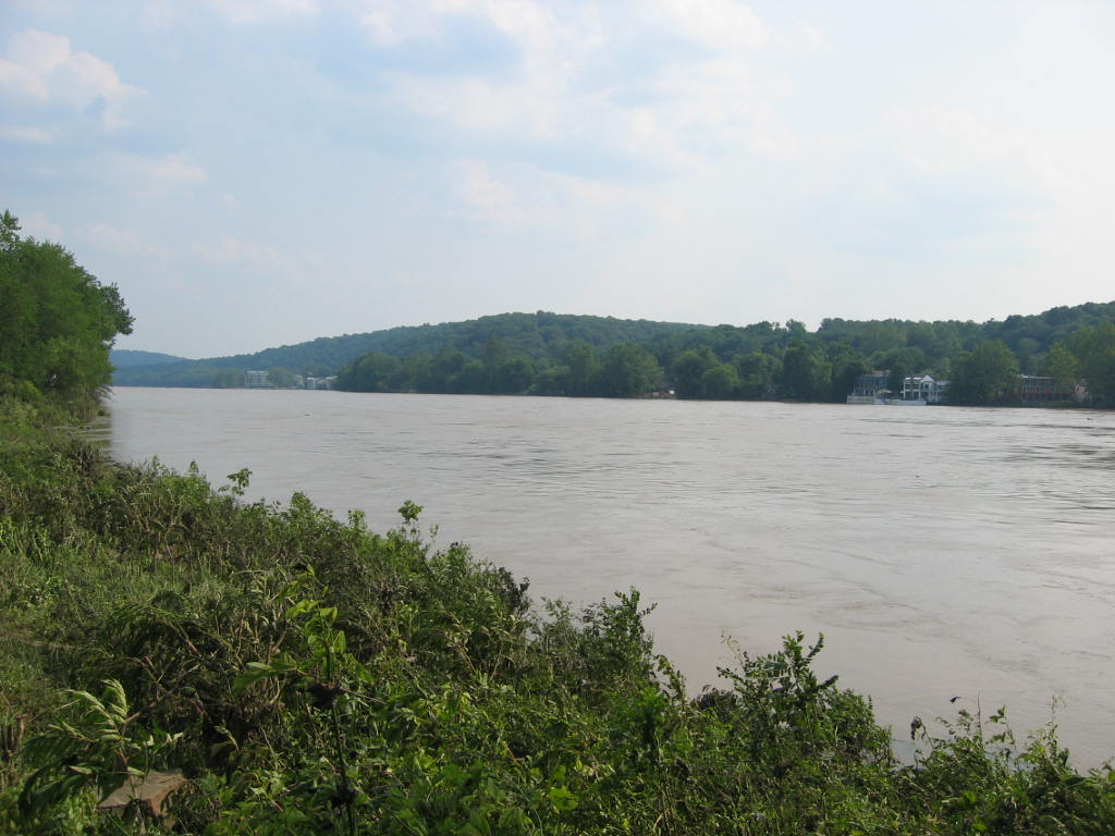
The picture of the River is taken from this same parking lot, looking south, towards Trenton. If you stand and watch the River long enough after a flood, you will see all kinds of debris in the river. It is very awesome to think that the spot where I was standing was probably under a few feet of water. I got a small taste of the power of the River.


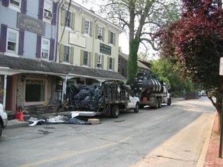
The street, is Lambert La, if memory serves, and is across the street from the Lambertville Station. It is a mix of commercial and residential. The afternoon we were there, some haz mat vehicles were still on site. Lambert Lane borders the River. This street was still blocked off the day we were there, and the free bridge was still closed, barricaded by the police. I took the liberty of quickly stepping over the yellow tape to take this picture.

Other river towns along the both sides of the Delaware were flooded, we went to Lambertville because the road was open. For the geographically inclined, here is a map. I hope this works, it is supposed to be a google map showing both the roads and the satellite view.
Monday, July 03, 2006

Floods part 2

The flood waters on the Delaware River have receded. I went to one of the river towns over the weekend and took some pictures. I need to spend a little time learning how to post pictures here. So, be patient, and I'll try to do this in a day or so. In the meantime, you may go here to see some pictures.

I ran into someone earlier this evening who lives in one of the towns along the Delaware. Her side of the street was dry, the other side was flooded. We talked about the River and what might be done about the flooding. We didn't come up with any answers.

More later.

Thursday, June 29, 2006

Floods Part 1

As I sit here, about fifteen miles east of the Delaware River in central New Jersey, the Delaware River is cresting. The third time in less than two years. Around here, the flood that every other flood is compared to is the 1955 flood. It doesn't look like the flooding will be as bad as 1955. And perhaps it won't be as bad as the floods of April 2005. And New Jersey is not alone. Other areas have been hit hard by flooding from the rains of the last few days - Maryland, New York, Pennsylvannia to name a few. Earler this year there was Massachusetts. And then there was New Hampshire last fall.

As I was reflecting on the floods and following news reports and flood reports, I found myself thinking about the latest round of floods and wondering about the reprecussions of these floods.

No, I don't mean the financial and emotional reprecussions of the areas impacted and the people who are impacted. I do want to say that I by no means diminish what they are going through. I can't even imagine it. Here in the NYC and Philadelphia media market, the floods are the leading story, as they probably are elsewhere. There are the arguments that we are all so familiar with about global warming leading to more frequent storms.

As a planner, and no I am not a "town planner", I find myself wondering if there is a better way to plan and prepare for floods and other natural disasters. Yes, we can have workable evacuation plans, shelters, good communications, financial help for cleaning up, etc. etc. But all the best plans and preparations won't make the floods go somewhere else. And people will die.

But I found myself thinking about the larger picture. And I come back to global warming. I don't have any answers. Just these incomplete thoughts that I am sharing here.

Of course, the people living along the Delaware probably don't give squat about global warming right now. And what I write isn't going to help them. But it helps me to express these thoughts here.