Showing posts with label fire weather. Show all posts

Wednesday, February 11, 2026

Snow Drought in Western U.S. Raises Increased Concerns About Wildfire Danger

According to the latest drought monitor New Jersey and surrounding areas are still experiencing a drought, however at least in New Jersey we have had a fair amount of snow this winter. Recently we saw frigid temperatures for several days with temperatures below freezing. But while we in New Jersey and environs are not out of a drought no one has raised concerns, at least not yet, about water shortages. I saw this video on the B10 NJ Wildland Fire Page today about a record snow drought in the Western U.S. raising concerns about water shortages and wildfire danger. 


Direct link to February 10th video from the Associated Press


Apologies for being very late in making my Wednesday post. 

Wednesday, February 04, 2026

Wildfire Behaviour: Fire Weather

Direct link to January 2024 video from World of Wildland Fire (WETC) on YouTube


Fuels, topography and weather are the important components in how a wildfire behaves. In a given area fuels and topography won't change but weather, aka fire weather, does change. I believe that this video is probably directed at wildland firefighters, perhaps as a part of their training, however I learned something and have a greater appreciation of what wildland firefighters, on the ground and in the air to keep us safe from wildfires. I hope that you find this video useful.

Monday, August 04, 2025

Dauntless Air on lightning


Direct link to August 4th post from Dautless Air on Facebook 


I saw these stunning photographs of lightning in the background with a Dauntless AT-802F Fire Boss aircraft in the foreground and could not resist sharing this with you. 

Friday, April 25, 2025

2025 New Jersey Wildfire Season: Increased Risk of Wildfires


Special Weather Statement
National Weather Service Mount Holly NJ
409 AM EDT Fri Apr 25 2025

NJZ001-007>010-012-013-015>022-027-PAZ054-055-060>062-070-071-
101>106-252300-
Sussex-Warren-Morris-Hunterdon-Somerset-Middlesex-
Western Monmouth-Mercer-Salem-Gloucester-Camden-
Northwestern Burlington-Ocean-Cumberland-Atlantic-
Southeastern Burlington-Carbon-Monroe-Berks-Lehigh-Northampton-
Delaware-Philadelphia-Western Chester-Eastern Chester-
Western Montgomery-Eastern Montgomery-Upper Bucks-Lower Bucks-
Including the cities of Newton, Washington, Morristown,
Flemington, Somerville, New Brunswick, Freehold, Trenton,
Pennsville, Glassboro, Camden, Cherry Hill, Moorestown,
Mount Holly, Jackson, Millville, Hammonton, Wharton State Forest,
Jim Thorpe, Stroudsburg, Reading, Allentown, Bethlehem, Easton,
Media, Philadelphia, Honey Brook, Oxford, West Chester,
Kennett Square, Collegeville, Pottstown, Norristown, Lansdale,
Chalfont, Perkasie, Morrisville, and Doylestown
409 AM EDT Fri Apr 25 2025

...Increased Risk of Rapid Fire Spread This Afternoon...

There is an increased risk for rapid fire spread this afternoon
across portions of New Jersey and eastern Pennsylvania. Minimum
relative humidity values will be around 25 to 35 percent combined
with southerly winds of 10 to 15 mph with gusts near 20 mph. High
temperatures will be in the mid 70s to near 80 degrees. These
conditions, along with the continued drying of fine fuels, could
support the rapid spread of any fires that ignite, which could
quickly become difficult to control.

Outdoor burning is strongly discouraged. Be sure to properly
extinguish or dispose of any potential ignition sources, including
smoking materials such as cigarette butts.

$$

Staarmann

Special Weather Statement
National Weather Service New York NY
332 AM EDT Fri Apr 25 2025

NJZ002-004-006-103>108-252300-
Western Passaic-Eastern Passaic-Hudson-Western Bergen-
Eastern Bergen-Western Essex-Eastern Essex-Western Union-
Eastern Union-
332 AM EDT Fri Apr 25 2025

...ELEVATED THREAT OF WILDFIRE SPREAD TODAY...

A dry air mass will combine with southerly winds to create
conditions more conducive for fire spread late this morning into
this afternoon.

Relative humidity is expected to decrease to around 30 percent
during this time, while wind gusts increase to 20 mph. These
conditions would likely aid fire spread if ignition occurs.

This forecast considers meteorological, fuel, and land conditions
and has been developed in coordination with state fire and land
management officials.

Listen to NOAA All Hazards Weather Radio or visit our web Site at
http://weather.gov/nyc for further details or updates.

$$

Monday, May 20, 2024

About Remote Automated Weather Stations (RAWS)

Direct link to video from National Interagency Fire Center on YouTube

Several years ago I learned about Remote Automated Weather Stations (RAWS), automated weather stations located around the United States, where I am able to obtain weather observations. I use weather information from RAWS in addition to the observations that I can obtain from my local Weather Forecast Office. One source of RAWS observations is MesoWest where you can click on a State you are interested in and select "RAWS" in the "network box" on the top left, or you may use the drop down box. For example. I have accessed RAWS data for New Jersey from MesoWest that may be found here. In my explorations just now as I was preparing to write this post, I found a National RAWS Archive for the United States with a clickable map.

To be completely honest while I sometimes use RAWS observations for my own personal information, I am also very interested in how RAWS are used to aid in fire weather forecasts, both permanent RAWS stations and Incident Remote Automated Weather Stations that are used by Incident Meterologists. The National Interagency Fire Center has a network of about 2,200 RAWS stations that includes most of the RAWS sites on MesoWest  used to aid fire weather forecasters among other uses. 

I hope that you have watched or will watch the four minute video from NIFC that I embedded above to learn about how fire weather forecasters and incident meterologists (IMETS) use RAWS and or the portable Incident RAWS (IRAWS). Note the IRAWS are also used for hurricane forecasting, and in responding to other natural or man made disasters.. You may also want to read the NIFC page on RAWS which includes a link to the video on this NIFC webpage. 

Monday, April 29, 2024

What Causes Wildfires from the US National Weather Service

Good information from the National Weather Service on what causes wildfires that was shared by the US National Weather Service IMET on April 22nd, I am embedding the original post from the US National Weather Service so you may see their description on what causes wildfires along with their really great graphic.


Friday, July 29, 2022

Drought conditions in the Northeastern United States (July 28th)


While not nearly as extreme as drought conditions in portions of the Southwestern and Western United States, drought conditions are worsening in the Northeastern United States. As you know, an increase in drought conditions means an increase in wildfire danger, I share first the map for May 31st for the Northeastern United States from the U.S. Drought Monitor. Note the abnormally dry and moderate dry conditions in New England with a portion of western New York, and smaller sections of southern New Jersey and West Virginia being abnormally dry. I can attest to at least a more normal rainfall in my little corner of Northwest New Jersey.


Bring June on and by the end of June I can also attest that the rain faucet in my little corner of Northwest New Jersey ceased to barely a trickle. As you can see, the July 5th map of the Northeast from the U.S Drought Monitor shows that more of New Jersey, including portions of Northwest New Jersey were abnormally dry. Meanwhile abnormally conditions spread in western New York. Finally abnormally dry and moderate conditions spread in New England


As most of you know we experienced a string of hot and humid weather with many areas of New Jersey receiving little or no rainfall through July 26th. I was not surprised to see that portions of Northwestern New Jersey are no in moderate drought. As for what next week's maps have in store for my portion of New Jersey, time will tell. I can say that I saw some more significant rainfall this week but am uncertain what the rest of moderate drought stricken areas of New Jersey received. Time will tell. In the meantime, I am trying to be both wildfire aware and do my part to reduce the increased wildfire risk from recent drought conditions.  I no longer smoke and have little if any reason to park on a pile of leaves, and am not aware that my car is dragging a muffler or the like. I am also trying to conserve water as I can and judiciously water a tree and a shrub that are especially stressed after a week of hot weather with almost not rain through July 26th. I am hoping that the rain I got on July 27th and 28th does not leave me feeling cocky and letting my guard down. As I am sure is the case in other states in the Northeast affected by worsening drought conditions, the New Jersey Forest Fire Service has imposed outdoor fire restrictions. I am also aware that we in the Northeast are not facing the very extreme years long drought conditions in portions of the Southwestern and Western United States.


Wednesday, June 08, 2022

About how clouds affect fire weather

This week the National Interagency Fire Center (NIFC) is sharing some information about how clouds affect fire weather on their Facebook and Twitter accounts. I will share some of their information that NIFC posted on their Twitter account.


Friday, April 22, 2022

2022 NJ wildfire season: enhanced fire danger

I wrote on April 8 reflecting on then recent rainfall wondering if drought conditions in New Jersey would diminish. The answer is yes, most of New Jersey is no longer under drought conditions. Only southern New Jersey is abnormally dry. While I am happy that my area of New Jersey is no longer seeing drought conditions, I am aware that wild fire danger is always present.

Obtained on April 22, 2022 from https://droughtmonitor.unl.edu/CurrentMap/StateDroughtMonitor.aspx?NJ

Dry conditions can exacerbate fire danger, but fire danger exists without a drought because other factors such as high winds and low relative humidity values play into wildfire danger. And fuels and soil can dry quickly after a rainfall. Today we in New Jersey are under enhanced fire weather warnings. I want to thank the New Jersey Forest Fire for all that they will do today to keep us in New Jersey as safe as we can be from wildfires. Be safe out there.


Special Weather Statement

National Weather Service Mount Holly NJ

405 AM EDT Fri Apr 22 2022

...Enhanced Threat for Fire Spread Today...

The combination of lower humidity values, breezy conditions, and drying fine fuels will lead to an enhanced threat for fire spread today across portions of eastern Pennsylvania, New Jersey, Delaware, and eastern Maryland. Relative humidity values are forecast to drop into the 20s to around 30 percent, while winds will gust out of the northwest around 20 to 25 mph at times.

Residents are urged to exercise caution handling any potential ignition source, including machinery, cigarettes, and matches. Be sure to properly discard all smoking materials. Any dry grasses and tree litter that ignites will have the potential to spread fire quickly.

For more information about wildfire danger, burn restrictions, and wildfire prevention and education, please visit your state forestry or environmental protection website.


Monday, April 11, 2022

About fire weather: learn about mixing height

Thanks to my friends at the NWS Incident Meteorologists for sharing this very informative video from Dr. Darren Clabo, Fire Meteorologist for South Dakota, on a fire weather parameter known as the mixing height. I obtained this link from the NWS IMET office in an April 9th post on their Facebook page, unfortunately I am not able to post a direct link to that post. I do read fire weather forecasts and have run across this term and only had a very basic knowledge of what the mixing height referred to. Now, thanks to Dr. Clabo, I know some more. Allow just under 20 minutes to watch the video, it is well worth your time.


Direct link to video from South Dakota Fire Weather

Friday, April 08, 2022

Reflections on recent rainfall and spring wildfire season in New Jersey

When the US Drought Monitor released their weekly map of drought conditions in the United States on Thursday, April 7th (valid for April 5th), I was not surprised to see that southern New Jersey remains under a moderate drought and the rest of New Jersey continues as abnormally dry. While we had what may have been a normal amount of rain last week, it was not enough to change drought conditions in New Jersey. So if we only look at current drought conditions, it might seem that New Jersey remains dry and with spring wildfire season either currently under way or under way soon then these apparent dry conditions may not bode well for the spring wildfire season.

Obtained on April 8, 2022 from https://droughtmonitor.unl.edu/

According to the main page of the Drought Monitor website, "the data cutoff for Drought Monitor pas is each Tuesday at 8 a.m. EDT. The maps, which are based on analysis of the data, are released each Thursday at 8:30 a.m. Eastern Time.

However, New Jersey has experienced two low pressure systems since Tuesday evening April 5th bringing a great deal of rain to much of New Jersey. Since the cutoff for data is 8 a.m. on Tuesdays, I feel safe in saying that the rainfall that we got in New Jersey occurred after the cutoff for the April 7, 2022 U.S. Drought Monitor Map. By the way, I checked with someone at my local NWS Weather Forecast Office in the in Mt. Holly NJ who told me that I was correct in saying that Tuesday's rainfall in New Jersey started Tuesday evening. 

I wonder if this rainfall may alleviate the drought in New Jersey? I am unable to provide a definitive answer to this question while we await for the U.S. Drought Monitor to come out with new maps next Thursday, April 14th, I turned to the NWS Middle Atlantic River Forecast Center because they monitor water supply and precipitation, among other things, across the river basins in their forecast area. 

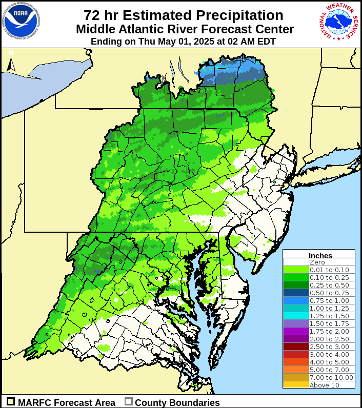
The NWS Middle Atlantic River Forecast Center (NWS MARFC) has two types of precipitation data that might be helpful. The first are maps showing 24, 48 and 72 hour accumulated rainfall across the river basins included in their forecast area . The map that I am sharing here is the 72 hour estimated precipitation from the NWS MARFC for the 72 hours ending at 1 PM on Friday, April 8, 2022. Note the dark purples, reds and oranges in New Jersey, indicating rainfall in excess of 1.75 inches with some areas having estimated precipitation of 2.5 inches or more


Obtained on April 8, 2022 from https://www.weather.gov/images/marfc/mpe/past72.png

I had a conversation with the hydrologists at the NWS MARFC who reminded me of their precipitation departure maps. As the name implies, these maps show precipitation departures from normal across their forecast area. They produce these maps for varying time periods from 7 days up to the last 365 days. I choose the year to date map for New Jersey to share with you (January 1, 2022 through April 7, 2022). If we continue to have rainfall close to average in the immediate future, and we may not, there is cause for some optimism as many counties in New Jersey havre precipitation departures just above average or less than an inch below average. Only two counties have precipitation departure of minus one inch or more.

Obtained on April 8, 2022 from https://www.weather.gov/marfc/NJPrecipitationYTD


So I am cautiously optimistic that we may be close to turning the corner from abnormally dry or moderate drought conditions to a better situation in southern NJ and normal conditions (no drought or dry conditions) in central and northern NJ. Time will tell, I will be back next week with an up date on drought conditions in New Jersey. By the way, I am aware that we in New Jersey and elsewhere in the northeast are relatively lucky as there are extreme drought conditions in the western U.S. 


Wednesday, October 27, 2021

About Firestorms

As regular readers know, I am always interested in learning more about weather as affects wildland firefighting and as affects the development of a wildfire. I would like to thank my friends at the NJFFS Section B10 website who a great video several days ago on firestorms. The video is part of a series called Weather Classroom by KREM 2 News, out of Spokane Washington, Meteorologist Thomas Patrick. The video that I am sharing with you is about Firestorms, based on Fire storms that burned near Spokane in October, 1991. While the wildfires he is speaking about burned in Washington and Orego, I think that his discussion is good science that can apply in areas outside of those States. Enjoy. Allow about 10 minutes to watch the video,

Direct link to video on YouTube from KREM 2 News

Monday, September 27, 2021

NWS Incident Meteorolgist demonstrating balloon launch

One of the tools that National Weather Service Incident Meteorologists (IMETS) have in their tool kit is the ability to launch weather balloons. I have shared videos of IMETS launching balloons in years past, but I think this bears repeating. Listen to NWS Incident Meteorologist Trainee Blaine Britreiter explain balloon launches in this eight minute video. If you prefer, a direct link to the video may be found on this Lassen National Forest FB Page.


Wednesday, June 30, 2021

2021 wildfire season: severe drought conditions in western U.S.

I am sure that most of you are aware of the severe drought conditions in most of the western United States coupled with historic heat wave, some say the worst drought in at least 20 years in places. I am not here to report on these conditions as many media outlets and related news and wildland fire news on the internet are doing so. However, here are a couple of articles that I found today for you: ABC News and The Hill

I am here because all in the wildland firefighting community, whether you be on the ground or in the air, to know that I am paying attention. 

I am here because what I have read in the coverage of the severe drought in the western U.S. scares me as the summer wildfire season is well under way. 

I am here because I want to tell my wildland firefighter friends that I can not imagine what is like to fight a wildfire in extreme heat. 

I am here because it is my prayer that all of you who are wildland firefighters whether you are on the ground, in the air, and various and asundry support staff are safe. I care.

I believe that one picture is worth a thousand words. Here are three images of significant wildfire potential outlook for July, August, and September from Predictive Services at the National Interagency Fire Center and two images showing drought conditions, one is the most recent drought monitor is the seasonal drought outlook from the Climate Prediction Center. In all cases, I am sharing the most recent images. These sites are updated with new information as appropriate so if you are coming here sometime in the future what you see at these sites may be different.


Monday, July 15, 2019

wildland firefighter safety: weather

I started writing about wildland firefighter safety last month, see this article for a synopsis including links to earlier articles in this series. One of the important considerations for wildland firefighter safety is weather. I am embedding another video from the WFSTAR series from the National Wildfire Coordinating Group. My understanding is that the WFSTAR series of videos are used in wildland firefighter training, initial and/or refresher training. I have embedded WFSTAR videos in some of my earlier articles in this series.

Today's video is called Weather and Wind Warnings. In the video, you will hear Heath Hockenberry, National Fire Weather Program Leader, discuss weather and wind warnings and how to stay weather aware. While perhaps aimed at wildland firefighters, I think that anyone interested in wildland firefighting and how wildland firefighters stay safe will enjoy this video. And any weather geeks, like me, will also enjoy the video. In addition to discussing weather and wind warnings, Heath refers to Incident Meteorologists (IMETs) when these specially training National Weather Service Meteorologists are deployed to wildfires. I learned how wildland firefighters stay weather aware whether or not an IMET is deployed to their fire.

If a wildfire does not have an IMET deployed to their wildfire, incident commanders, supervisors and and others will be in touch with the local National Weather Service Weather Forecast Office for forecasts and as appropriate spot forecasts specific to the area where the wildfire is. The forecasts will be relayed to wildland firefighters in assembled briefings and/or over the radio.

After I saw Heath's video on weather and wind warnings, I wrote my friends at the IMET Office telling them what I was doing and asking Heath the following question:

Random Ramblings: Heath, what is one thing that you would like my readers to take away from this video?

Heath: I would say one of the key items found in the video is the section on personal responsibility. Your meteorologist's forecast can take you 90% of the way in understanding the type of conditions you can expect on a fire line. The last 10% of the way consists of watching for cumulus buildups, or watching the tops of the trees, or being aware of subtle changes in wind speeds and/or directions. Weather in complex terrain is highly variable and your IMET is there to provide the fire environment foundation. The actual experience of the weather rests upon that foundation, and personal situational assessment is key to minimize fire fighting dangers related to weather.

Allow just under thirteen minutes to watch the video. I don't know about, you I watched the video a couple of times.


Direct link to Weather and Wind Warnings from Youtube

I am still thinking about and doing background research for other articles in this series on wildland firefighter safety. Stay tuned.

Wednesday, January 09, 2019

About NWS Warnings with attention to fire weather

Some of you may have notice that in the last day I have a new page on this blog, NWS Advisories, Watches & Warnings, where I have posted a long article that I wrote called National Weather Service Advisories, Watches, & Warnings with a Focus on Fire Weather.

Late last summer I got in a conversation with a couple of friends of mine about the difference between Fire Weather Watches and Red Flag Warnings issued by local National Weather Service (NWS) Weather Forecast Offices (WFO). I wanted to give them some good information so with the help of a couple friends from a couple of NWS WFO including my very own NWS Mt Holly WFO, I made some notes about Fire Weather Watches and Red Flag Warnings. To make a long story short, I did more reading on NWS websites. As I read more, I realized that I wanted to expand my notes into a longer article with the intention of providing information for the general public about various NWS advisories, watches and warnings focusing on fire weather.

The result is an article that is a little over six pages on my word processor. I was helped along the way by several NWS meteorologists from NWS WFOs around the country, including the Mt. Holly (Philadelphia) WFO. In addition, I was helped by a retired NWS meteorologist. They answered my questions, and provided new insights and where there when I wanted to know if my thinking was correct.

I hope that some of you find this article useful. It is my hope that this article will apply to those of you in rural as well as suburban and urban areas. Further while there is a special focus on fire weather; some of the advisories, watches and warnings I write about apply in situations where there are no current or recent wildland fires. There are numerous NWS links in the article that you can refer to for further information.

You will note that I refer to this article near the top right hand side of my blog for ease of reference. 

Tuesday, May 08, 2018

Southern Great Plains (OK) Elevated Fire Weather: week of May 7th

Sorry folks, I meant to post this yesterday.

I haven't forgotten about my friends in Oklahoma. I understand that they are expected to see elevated fire weather conditions for this week, the week of May 7th. See this Facebook post from the NWS Norman Oklahoma from earlier today, May 7th to see the fire conditions

I took a screen shot for you from the Oklahoma Forest Fire Service Daily Situation for May 7th (go here for a better copy of the report (PDF file). I will try to stay aware of wildfires that might crop in Oklahoma and environs this week.


Tuesday, February 27, 2018

Wildfire activiity in Southern Great Plains - Texas

I wrote yesterday (February 26th) about critical fire weather in the Southern Great Plains. Critical Fire Weather continues today in a portion of the Southern Great Plains.

Fire Weather Outlook for February 27, 2018 issued by NWS Storm Prediction Center on February 27, 2018

I don't know of any significant wildfire activity that occurred in Oklahoma yesterday, February 26th. I suspect that there may well be smaller wildfire in Oklahoma yesterday that I am not aware of.

There were at three larger wildfires in Texas on February 26 according to the Southern Area Coordination Center's (SACC)Morning Report for February 27th (the current morning report is found under Southern Area Productions):
  • Head 2, Fire started on February 25th, 300 acres is 100 percent contained.
  • Newell Fire, started on February 26th. According to this Texas A&M Forest Service Incident Information Twitter Post burned 4,022 acres up from the 2,500 acres reported by the SACC earlier this morning.
  • 57 North Fire started on February 26th, 700 acres burned is 100 percent contained.
Enjoy this Youtube video posted earlier this afternoon by the Texas A&M Forest Service. taken from the cab of a dozer by Resource Specialist Cody Lambert as he worked the 57 North Fire


This just in from the Texas A&M Forest Service at about 5:25 EST

Monday, February 26, 2018

Critical Fire Weather continues in Southern Great Plains

Critical Fire Weather continues in portions of the Southern Great Plains today. It is still too early to know about any new wildfire activity today in Oklahoma, Texas, and environs. I'll report back if there is substantial new wildfire activity to report, probably tomorrow (February 27th).

Fire Weather Outlook for February 26, 3028 issued by the NWS Storm Prediction Center on February 26, 2018

Monday, February 19, 2018

Oklahoma and Texas Wildfires - February 16 to 18

I heard of three wildfires in Oklahoma and Texas, one that burned at the end of last week (week ended February 16th) and two that were reported on February 18th. There may well have been more wildfires that I do not know about.

Kemohah Fire, near Hominy Oklahoma, 166 acres, one structure destroyed. Reported by Bill Gabbert of Wildfire Today on February 16, 2017. To the best of my knowledge, this  grass/vegetation fire is contained. It apparently started as a structure fire before spreading to burn 166 acres.

136 Fire, Potter County Texas, (Highway 136 and Cass Johnson Road) was one of a four wildfires (grass?) that were reported and on or about February 18th, most are at or near containment. My understanding is that the 136 fire, a grass fire, was contained at about 10 acres with the help of three air tankers dropping on the grass fire. The Texas A&M Forest Service made three tweets on twitter about this fire all on February 18th: tweet #1 at 11:24 AM on February 18th, tweet #2 at 12:01 PM on February 18th, and finally in tweet # 3 at 2:07 PM  on February 18th they reported that the fire had burned 10 acres and was at 90 percent containment. Thanks to Mike Archer at Wildfire News of the Day for the link to an article with video from MyHighPlains (February 18, 2018) about the 136 fire and the other wild (grass) fires.

Red Horse Fire, Woods County Oklahoma, about 2,549 acres at 35 percent containment, started on or about February 18th. I first learned about the Red Horse Fire from the Oklahoma Forest Service's Daily Situation Report (Facebook) for February 19, 2018. A direct link to the OFS Daily Situation Report may be found on the February 19th entry on the OFS Fire Blog. I found two local media reports about the Red Horse Fire: Woodward News (February 18th) and NewsOK (February 18th). Thanks to Mike Archer at Wildfire News of the Day for the link to the Woodward News article.

The early reports that I saw about the Red Horse Fire from yesterday and early this morning (February 19th) reported that about 3,600 acres were burned. at some point the acreage burned was downgraded to 2,549 acres probably because of better mapping. As I was writing this, I saw the following post on the OFS Facebook page probably posted about 2:45 PM EST.


High 34 and 73 Fire, Rogers Mills County, Oklahoma, 400 acres. I wrote about this wildfire on February 16th, I have no further information on containment.

Critical Fire Weather Continues in portions of Oklahoma, Texas, and surrounding areas


Fire Weather Bundle for days 1-2, 3-8 obtained on February 19, 2018 from http://www.spc.noaa.gov/gis/

Fire Weather Bundle for days 1-2, 3-8 obtained on February 19, 2018 from http://www.spc.noaa.gov/gis/