
When the US Drought Monitor released their weekly map of drought conditions in the United States on Thursday, April 7th (valid for April 5th), I was not surprised to see that southern New Jersey remains under a moderate drought and the rest of New Jersey continues as abnormally dry. While we had what may have been a normal amount of rain last week, it was not enough to change drought conditions in New Jersey. So if we only look at current drought conditions, it might seem that New Jersey remains dry and with spring wildfire season either currently under way or under way soon then these apparent dry conditions may not bode well for the spring wildfire season.
 |
| Obtained on April 8, 2022 from https://droughtmonitor.unl.edu/ |
According to the main page of the Drought Monitor website, "the data cutoff for Drought Monitor pas is each Tuesday at 8 a.m. EDT. The maps, which are based on analysis of the data, are released each Thursday at 8:30 a.m. Eastern Time.
The NWS Middle Atlantic River Forecast Center (NWS MARFC) has two types of precipitation data that might be helpful. The first are maps showing 24, 48 and 72 hour accumulated rainfall across the river basins included in their forecast area . The map that I am sharing here is the 72 hour estimated precipitation from the NWS MARFC for the 72 hours ending at 1 PM on Friday, April 8, 2022. Note the dark purples, reds and oranges in New Jersey, indicating rainfall in excess of 1.75 inches with some areas having estimated precipitation of 2.5 inches or more
 |
| Obtained on April 8, 2022 from https://www.weather.gov/images/marfc/mpe/past72.png |
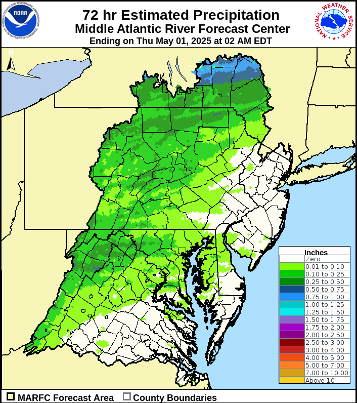
I had a conversation with the hydrologists at the NWS MARFC who reminded me of their precipitation departure maps. As the name implies, these maps show precipitation departures from normal across their forecast area. They produce these maps for varying time periods from 7 days up to the last 365 days. I choose the year to date map for New Jersey to share with you (January 1, 2022 through April 7, 2022). If we continue to have rainfall close to average in the immediate future, and we may not, there is cause for some optimism as many counties in New Jersey havre precipitation departures just above average or less than an inch below average. Only two counties have precipitation departure of minus one inch or more.
 |
| Obtained on April 8, 2022 from https://www.weather.gov/marfc/NJPrecipitationYTD |
So I am cautiously optimistic that we may be close to turning the corner from abnormally dry or moderate drought conditions to a better situation in southern NJ and normal conditions (no drought or dry conditions) in central and northern NJ. Time will tell, I will be back next week with an up date on drought conditions in New Jersey. By the way, I am aware that we in New Jersey and elsewhere in the northeast are relatively lucky as there are extreme drought conditions in the western U.S.
No comments:
Post a Comment